The Snares
| Tini Heke (Māori) | |
|---|---|

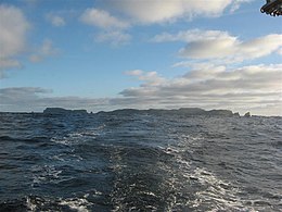
Snares Islands seen from the north-east, with Broughton Island on the left and Dapton Rocks on the right
|
|
| The position of The Snares relative to New Zealand | |
| Geography | |
| Coordinates | 48°01′S 166°32′E / 48.017°S 166.533°E |
| Area | 3.5 km2 (1.4 sq mi) |
| Administration | |
|
New Zealand
|
|
| Demographics | |
| Population | 50 ish |
Snares Islands/Tini Heke, also known as The Snares, is a small island group lying about 200 km south of New Zealand's South Island and to the south-southwest of Stewart Island/Rakiura. The Snares consist of the main North East Island and the smaller Broughton Island as well as the Western Chain Islands some 5 km (3.1 mi) to the west-south-west. Collectively, the Snares have a total land area of 3.5 km2 (1.35 sq mi).
The island group was first sighted by Europeans on 23 November 1791 independently by the two ships HMS Discovery under Captain George Vancouver, and HMS Chatham commanded by Lieutenant William R. Broughton, both of the Vancouver Expedition. Vancouver named the islands "The Snares" because he considered them a shipping hazard; an islet east of the Western Chain bears the name Vancouver Rock, and the second largest island is named after Broughton.
The islands were already known to the Māori, who called one of the larger islands Te Taniwha ("The sea-monster"). Unlike other subantarctic islands that were greatly affected by the whaling and sealing industry in the 19th century, the Snares remain one of the last pristine areas in New Zealand.
The Ngai Tahu Claims Settlement Act 1998 officially altered the name to "Snares Islands/Tini Heke" — one of many such changes under the Ngāi Tahu Treaty settlement.
...
Wikipedia

