The Pas, Manitoba
| Town of The Pas | ||
|---|---|---|

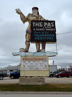
Welcome sign
|
||
|
||
| Motto: Adventure Territory | ||
| Coordinates: 53°49′30″N 101°15′12″W / 53.82500°N 101.25333°WCoordinates: 53°49′30″N 101°15′12″W / 53.82500°N 101.25333°W | ||
| Country | Canada | |
| Province | Manitoba | |
| Census division | 21 | |
| Region | Northern Region | |
| Incorporated (town) | 1912 | |
| Government | ||
| • Mayor | Jim Scott | |
| Area | ||
| • Land | 47.83 km2 (18.47 sq mi) | |
| • Urban | 14.15 km2 (5.46 sq mi) | |
| Elevation | 271 m (889 ft) | |
| Population (2011) | ||
| • City | 5,513 | |
| • Density | 115.3/km2 (299/sq mi) | |
| • Urban | 5,689 | |
| • Urban density | 402.1/km2 (1,041/sq mi) | |
| Time zone | CST (UTC−5) | |
| • Summer (DST) | CDT (UTC−6) | |
The Pas (/ðəˈpɑː/; French: Le Pas) is a town in Manitoba, Canada, located at the confluence of the Pasquia River and the Saskatchewan River within Division No. 21 in the Northern Region. It is approximately 630 km (390 mi) northwest of the provincial capital, Winnipeg, and 40 km (25 mi) from the border of Saskatchewan. It is sometimes still called Paskoyac by locals after the first trading post, called Fort Paskoya and constructed during French colonial rule. The Pasquia River begins in the Pasquia Hills in east central Saskatchewan. The French in 1795 knew the river as Basquiau.
Known as "The Gateway to the North", The Pas is a multi-industry northern Manitoba town serving the surrounding region. The main components of the region's economy are agriculture, forestry, commercial fishing, tourism, transportation, and services (especially health and education). The main employer is a paper and lumber mill operated by Canadian Kraft Papers. The Pas contains one of the two main campuses of the University College of the North.
The Pas is bordered by the Rural Municipality of Kelsey, as well as part of the Opaskwayak Cree Nation.
...
Wikipedia


