The Mallee
|
Mallee Victoria |
|||||||||||||
|---|---|---|---|---|---|---|---|---|---|---|---|---|---|

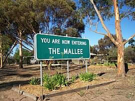
Entering The Mallee, along the Sunraysia Highway.
|
|||||||||||||

An outline of the Mallee (yellow) and Sunraysia (pink) districts.
|
|||||||||||||
| Population | 81,544 (2011 census) | ||||||||||||
| • Density | 2.02932/km2 (5.25590/sq mi) | ||||||||||||
| Area | 40,183 km2 (15,514.7 sq mi) | ||||||||||||
| LGA(s) | |||||||||||||
| State electorate(s) | |||||||||||||
| Federal Division(s) | Mallee | ||||||||||||
|
|||||||||||||
The Mallee is an ill–defined district, sometimes incorrectly referred to as an economic region, of the Australian state of Victoria. The district is located entirely within the Loddon Mallee region; and covers the most northwesterly district in the state bounded by the South Australian and New South Wales borders, inclusive of the Murray River.
Definitions of the district vary, however all are based on the Victorian distribution of mallee eucalypts. These trees dominate the surviving vegetation through most of Mallee, except for swamps and areas along waterways, and the very rare stands of intact Casuarina.
At the 2011 census, the four local government areas (LGAs) that are thought to comprise the ill–defined district had a combined population of 81,544. The area of these same four LGAs is 40,183 square kilometres (15,515 sq mi).
In the context of the Interim Biogeographic Regionalisation for Australia, the Mallee is spread over parts of both the Murray Darling Depression and Riverina bioregions. Some definitions of the Mallee extend the district into South Australia, which is called Murray Mallee.
The Mallee is one of the nine districts in Victoria used for weather forecasting by the Australian Bureau of Meteorology.
The Victorian Department of Environment and Primary Industries defines the district as a 39,300-square-kilometre (15,200 sq mi) region for agricultural production purposes encompassing the Buloke, Gannawarra, Mildura City and Swan Hill City local government areas.
...
Wikipedia
