The Actions of St Eloi Craters
| Actions of St Eloi Craters | |||||||||
|---|---|---|---|---|---|---|---|---|---|
| Part of the First World War | |||||||||
 St Eloi |
|||||||||
|
|||||||||
| Belligerents | |||||||||
|
|
|||||||||
| Commanders and leaders | |||||||||
| Douglas Haig | Erich von Falkenhayn | ||||||||
| Units involved | |||||||||
| 3rd Division, 2nd Canadian Division | 46th Reserve Division | ||||||||
| Casualties and losses | |||||||||
| 2,233 | 1,605 | ||||||||
|
|
|||||||||
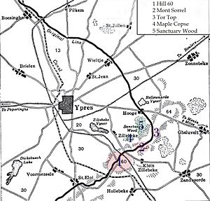
The Actions of St Eloi Craters were local operations carried out in the Ypres Salient of Flanders, during the First World War by the German 4th Army and the British Second Army from 27 March – 16 April 1916. Sint-Elooi (commonly called St Eloi in English) is a village about 5 km (3.1 mi) south of Ypres in Belgium. The British dug six galleries under no man's land and placed large explosive charges under the German defences and blew the mines at 4:15 a.m. on 27 March 1916. Troops of the 27th Division attacked and captured all but craters 4 and 5. The 46th Reserve Division counter-attacked but craters 4 and 5 were lost to the British on 30 March. British attacks continued into early April and then the Canadian Corps took over with the 2nd Canadian Division, despite the disadvantage of relieving troops in the middle of a military operation.
The Canadians inherited positions in a deplorable state, the British having attacked to press their advantage, rather than consolidated the captured ground and on the night of 5/6 April a German methodical attack (Gegenangriff) recovered the ground and captured craters. It was difficult for Canadian runners to take messages back reporting the situation and for several days the Canadian and British staffs were ignorant of which craters had been captured, the topography having been changed so much by the mine detonations. There were 17 craters, the new ones superimposed on the old, the ground around full of shell-holes and part-demolished trenches; if people raised their heads in daylight, they were sniped, which made it impossible to orientate. craters 2, 3, 4 and 5 were the biggest but fresh troops easily mistook one pair of craters for another.
...
Wikipedia

