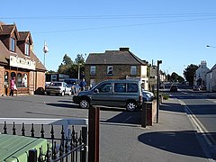
Teynham
| Teynham | |
|---|---|
 The A2 London Road, part of the most densely populated area |
|
| Teynham shown within Kent | |
| Population | 2,904 (2001) 2,913 (2011) |
| OS grid reference | TQ952628 |
| Civil parish |
|
| District | |
| Shire county | |
| Region | |
| Country | England |
| Sovereign state | United Kingdom |
| Post town | SITTINGBOURNE |
| Postcode district | ME9 |
| Dialling code | 01795 |
| Police | Kent |
| Fire | Kent |
| Ambulance | South East Coast |
| EU Parliament | South East England |
| UK Parliament | |
Teynham (/ˈtɛnəm/ TEN-əm) is a large village and civil parish in the borough of Swale in Kent, England. The parish lies between the towns of Sittingbourne and Faversham, immediately north of the A2 road, and includes the hamlet of Conyer on an inlet of the Swale, the channel that separates mainland Kent from the Isle of Sheppey. Other hamlets include Deerton Street, Frognal, and Teynham Street.
The village has a railway station, served by Southeastern trains running between London Victoria and Dover.
Charters of 798 to 801 and Domesday Monachorum – a series of Domesday-related texts kept at Canterbury Cathedral – mention it as Teneham, Taenham, Tenaham and Tenham. In Domesday Book the name occurs as "Therham" (probably a clerical error).
The historian JK Wallenberg (in 1931) suggests an Anglo-Saxon root, tynan, to enclose, followed by the Anglo-Saxon word "Hamm", a land drained by dykes. Another historian, Eilert Ekwall (in 1936), suggests an early owner named Teona, whose name is found in Teonanhyll in Berkshire.
In 1590, William Lambarde wrote his book Perambulation of Kent, in which Tenham is called the towne of ten houses. He also notes that in 1533, 105 acres of good ground in 'Brennet' (a former name of Tenham, were divided in ten parcels of land to grow fruit for King Henry.
...
Wikipedia

