Isle of Sheppey
| Isle of Sheppey | |
|---|---|
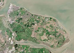
 Sheppey as seen by the Operational Land Imager |
|
| Isle of Sheppey shown within Kent | |
| Area | 93 km2 (36 sq mi) |
| Population | 40,300 (2011 Census) |
| • Density | 433/km2 (1,120/sq mi) |
| OS grid reference | TQ970695 |
| District | |
| Shire county | |
| Region | |
| Country | England |
| Sovereign state | United Kingdom |
| Post town | SHEERNESS |
| Postcode district | ME11/ME12 |
| Dialling code | 01795 |
| Police | Kent |
| Fire | Kent |
| Ambulance | South East Coast |
| EU Parliament | South East England |
| UK Parliament | |
The Isle of Sheppey is an island off the northern coast of Kent, England in the Thames Estuary, some 46 miles (74 km) to the east of London. It has an area of 36 square miles (93 km2). The island forms part of the local government district of Swale. Sheppey is derived from the ancient Saxon "Sceapige", meaning isle of sheep, and even today the extensive marshes which make up a considerable proportion of the island provide grazing for large flocks of sheep.
Today's island was historically known as the "Isles of Sheppey" which were Sheppey itself, the Isle of Harty to the south east and the Isle of Elmley to the south west. Over time the channels between the isles have silted up to make one continuous island. Sheppey, like much of north Kent, is largely formed from London Clay and is a plentiful source of fossils. The Mount near Minster rises to 250 feet (76 metres) above sea level and is the highest point on the island. The rest of Sheppey is low-lying and the southern part of the island is marshy land criss-crossed by inlets and drains.
Some Sheppey inhabitants like to call themselves Swampies, a term that began as, and for some people remains, an insult; for others it has become a term of endearment or a phrase for reinforcing identity.
Sheppey is separated from the mainland by a channel called the Swale. Like the Wantsum Channel separating the Isle of Thanet from the mainland to the east, and Yantlet Creek at the Isle of Grain, it was used in ancient times by shipping to and from ports such as Chatham and London to reduce exposure to bad weather in the Thames Estuary or North Sea.
Three ferries have operated between the mainland and the isle: one to the west, called the King's Ferry; one at Elmley; and another, giving access from Faversham, the Harty Ferry. All had long histories: particularly the last (see external link below). None operate today: the Harty Ferry ceased operation at the start of the First World War, but the slipways at Harty and Elmley can still be seen today. That at Harty is below the Ferry House Inn (the landlord owns the ferry rights), while seeing the one at Elmley requires a walk of about a mile and a half from the RSPB car park. Additionally the South Eastern Railway operated a connecting passenger ferry to Sheerness from Port Victoria railway terminus on the Grain Peninsula for some years. Several ferry services to Southend have also been tried but proved short-lived. An attempt to start a small hovercraft service between the Harty Ferry Inn and Oare Creek near Faversham in 1970 by the then landlord, Ben Fowler, failed after a few days.
...
Wikipedia

