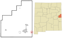
Texico, New Mexico
| Texico, New Mexico | |
|---|---|
| City | |

Grain elevator in New Mexico, wooden building in Texas
|
|
 Location of Texico, New Mexico |
|
| Location in the United States | |
| Coordinates: 34°23′28″N 103°2′54″W / 34.39111°N 103.04833°WCoordinates: 34°23′28″N 103°2′54″W / 34.39111°N 103.04833°W | |
| Country | United States |
| State | New Mexico |
| County | Curry |
| Area | |
| • Total | 0.8 sq mi (2.1 km2) |
| • Land | 0.8 sq mi (2.1 km2) |
| • Water | 0.0 sq mi (0.0 km2) |
| Elevation | 4,147 ft (1,264 m) |
| Population (2000) | |
| • Total | 1,065 |
| • Density | 1,299.0/sq mi (501.5/km2) |
| Time zone | Mountain (MST) (UTC-7) |
| • Summer (DST) | MDT (UTC-6) |
| ZIP code | 88135 |
| Area code(s) | 575 |
| FIPS code | 35-77250 |
| GNIS feature ID | 0915905 |
Texico is a city in Curry County, New Mexico, United States. The population was 1,130 at the 2010 census. The city is located on the Texas-New Mexico border with the town of Farwell, Texas across the border.
The name is a portmanteau of "Texas" and "New Mexico". Texico is located on the Texas-New Mexico border. The town of Farwell borders Texico on the Texas side of the border.
Texico is located on the high plains of Eastern New Mexico in a region known as the Llano Estacado. According to the United States Census Bureau, the city has a total area of 0.8 square miles (2.1 km2), all of it land.
As of the census of 2000, there were 1,065 people, 381 households, and 278 families residing in the city. The population density was 1,299.0 people per square mile (501.5/km²). There were 414 housing units at an average density of 504.9 per square mile (194.9/km²). The racial makeup of the city was 59.15% White, 4.60% African American, 1.22% Native American, 0.09% Asian, 0.09% Pacific Islander, 31.46% from other races, and 3.38% from two or more races. Hispanic or Latino of any race were 47.32% of the population.
...
Wikipedia

