Texas panhandle
| Texas Panhandle | |
| Region | |
|
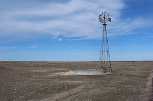
Windpump on the level plains of the Texas Panhandle
|
|
| Country | |
|---|---|
| State | |
| Region | High Plains |
| Highest point | |
| - location | Dallam County |
| - elevation | 1,440 m (4,724 ft) |
| - coordinates | 36°30′01″N 103°02′30″W / 36.50028°N 103.04167°W |
| Lowest point | |
| - location | Childress County |
| - elevation | 474 m (1,555 ft) |
| - coordinates | 34°34′20″N 100°00′01″W / 34.57222°N 100.00028°W |
| Area | 67,046 km2 (25,887 sq mi) |
| Population | 427,927 (2010) |
| Density | 6.4/km2 (17/sq mi) |
| Timezone | Central (UTC-6) |
| Area code | 806 |
|
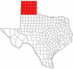
Map of the Texas Panhandle
|
|
| Website: Handbook of Texas: Panhandle | |
The Texas Panhandle is a region of the U.S. state of Texas consisting of the northernmost twenty-six counties in the state. The panhandle is a rectangular area bordered by New Mexico to the west and Oklahoma to the north and east. The Handbook of Texas defines the southern border of Swisher County as the southern boundary of the Texas Panhandle region, though some consider the region to extend as far south as Lubbock County. The Texas Panhandle Press Association accepts members in the actual panhandle and a triangle formed by its southern tier, the southeastern border of New Mexico and a diagonal to the beginning, which includes Lubbock County.
Its land area is 25,823.89 sq mi (66,883.58 km2), or nearly 10 percent of the state's total. The Texas Panhandle is slightly larger in size than the US State of West Virginia. There is an additional 62.75 sq mi (162.53 km2) of water area. Its population as of the 2010 census was 427,927 residents, or 1.7 percent of the state's total population. As of the 2010 census, the population density for the region was 16.6 per square mile (6.4/km2). The Panhandle is distinct from North Texas, which is farther southeast.
West of the Caprock Escarpment and north and south of the Canadian River breaks, the surface of the Llano Estacado is rather flat. South of the city of Amarillo, the level terrain gives way to Palo Duro Canyon, the second largest canyon in the United States. This colorful canyon was carved by the Prairie Dog Town Fork Red River. North of Amarillo lies Lake Meredith, a reservoir created by Sanford Dam on the Canadian River. The lake, along with the Ogallala Aquifer, provides drinking water and irrigation for this moderately dry area of the high plains.
...
Wikipedia


