Tetín u Berouna
| Tetín | |||
|---|---|---|---|
| Municipality and village | |||
 |
|||
|
|||
 |
|||
| Country |
|
||
| Region | Central Bohemian Region | ||
| District | Beroun District | ||
| Area | |||
| • Total | 3.97 sq mi (10.29 km2) | ||
| Population (2011) | |||
| • Total | 846 | ||
| • Density | 210/sq mi (82/km2) | ||
| Time zone | CET (UTC+1) | ||
| • Summer (DST) | CEST (UTC+2) | ||
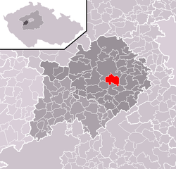
Tetín is a municipality and village in Beroun District in the Central Bohemian Region of the Czech Republic. It is about 2 kilometres from the city Beroun on the river Berounka. As of 2012, it has a population of 744 people.
Historically, Tetín is one of the oldest villages in the Czech Republic. The place was already inhabited during the paleolithic period. Archaeologists found that the beginnings of the town date back to the 10th century, but they are connected with the mythological figure Teta, the daughter of the mythological Duke Krok, who was supposed to have lived earlier than that. In the 10th century, there was a wooden building there belonging to the duchess St. Ludmila, who was murdered in 921. In the 11th and 12th century, the place was home to the administrative district of Tetín that governed the whole area of Podbrdsko. Tetín is also referenced in the Vyšehrad document.
In the year 1288, Tetín was the residence of the royal hunter and towards the end of the thirteenth century, the castle was rebuilt as a residence for the royal bastards of the Přemyslid line. By 1321, Tetín castle was owned by Štěpán from Tetín, who later sold it to Emperor Karel IV. The latter then joined the Tetín estate to Karlštejn. In 1422, during the Hussite wars, the castle was destroyed, and the place was heavily damaged in the 20th century by limestone mines. The Czech poet Jaroslav Seifert dedicated two of his poems to Tetín.
• Tetín Castle, from around 1288.
• Romanesque Church of St. Catherine of Alexandria from 1200.
• Romanesque Church of St. John of Nepomuk from around 1255.
• The Presbytery, from the 14th century.
• The early baroque Church of St. Ludmila from around 1780.
• The Palace, from the 18th century.
• The courtyard, from the 18th century.
• The nature reserve Tetínské skály.
• The national nature reserve Koda.
• The limestone hill Damil on which there are the remains of an ancient castle.
Coordinates: 49°56′35″N 14°05′39″E / 49.94306°N 14.09417°E
...
Wikipedia


