Teresópolis
|
Teresópolis Município de Teresópolis |
|||||
|---|---|---|---|---|---|

View from Pedra do Sino
|
|||||
|
|||||
| Nickname(s): Terê | |||||
| Motto: "Sub Digitum Dei" (Latin for, "Under God's Finger") |
|||||
Anthem:
|
|||||
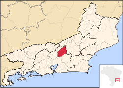
 Location of Teresópolis in the state of Rio de Janeiro |
|||||
| Coordinates: 22°24′43″S 42°57′57″W / 22.41194°S 42.96583°W | |||||
| Country | Brazil | ||||
| Region | Southeast | ||||
| State | Rio de Janeiro | ||||
| Founded | 1891 | ||||
| Government | |||||
| • Mayor | Arlei de Oliveira Rosa | ||||
| Area | |||||
| • Total | 770.6 km2 (297.5 sq mi) | ||||
| Elevation | 871 m (2,858 ft) | ||||
| Population (2010) | |||||
| • Total | 163,746 | ||||
| • Density | 212.5/km2 (550/sq mi) | ||||
| Time zone | UTC-3 (UTC-3) | ||||
| Website | teresopolis.rj.gov.br | ||||
Coordinates: 22°24′43″S 42°57′57″W / 22.41194°S 42.96583°W
Teresópolis (Portuguese pronunciation: [teɾeˈzɔpolis]) is a Brazilian municipality located in the state of Rio de Janeiro, in a mountainous region known as Região Serrana. The Serra dos Órgãos National Park lies partly within the city limits. The city is known as the home of the Brazilian national football team, since it hosts CBF's training ground at Granja Comary.
Before the arrival of the Portuguese to the area where Teresópolis lies today, in the 16th century, it was inhabited by Indians. In the following centuries, Portuguese started buying land there. The region was also occupied by a quilombo, formed by runaway slaves coming from sugar cane plantations near Rio de Janeiro.
In 1821, English citizen George March (born and raised in Portugal) established a farm there, which later became the most important settlement along the way between the court, in Rio de Janeiro, and the territory of Gerais (nowadays, the state of Minas Gerais), which led to the great improvement of agriculture and cattle raising.
...
Wikipedia


