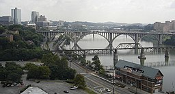
Tennessee river
| Tennessee River | |
| River | |
|
The Tennessee River in downtown Knoxville from the top of Neyland Stadium
|
|
| Country | United States |
|---|---|
| States | Tennessee, Alabama, Mississippi, Kentucky |
| Source | Confluence of French Broad and Holston rivers at Knoxville |
| - elevation | 813 ft (248 m) |
| - coordinates | 35°57′33″N 83°51′01″W / 35.95917°N 83.85028°W |
| Mouth | Ohio River at Livingston / McCracken counties, near Paducah, Kentucky |
| - elevation | 302 ft (92 m) |
| - coordinates | 37°04′02″N 88°33′53″W / 37.06722°N 88.56472°WCoordinates: 37°04′02″N 88°33′53″W / 37.06722°N 88.56472°W |
| Length | 652 mi (1,049 km) |
| Basin | 40,876 sq mi (105,868 km2) |
| Discharge | |
| - average | 70,575 cu ft/s (1,998 m3/s) |
| - max | 500,000 cu ft/s (14,158 m3/s) |
|
Map of the Tennessee River watershed
|
|
|
Tributaries, lakes, and cities associated with the Tennessee River
|
|
The Tennessee River is the largest tributary of the Ohio River. It is approximately 652 miles (1,049 km) long and is located in the southeastern United States in the Tennessee Valley. The river was once popularly known as the Cherokee River, among other names, as many of the Cherokee had their territory along its banks, especially in eastern Tennessee and northern Alabama. Its current name is derived from the Cherokee village Tanasi.
The Tennessee River is formed at the confluence of the Holston and French Broad rivers on the east side of present-day Knoxville, Tennessee. From Knoxville, it flows southwest through East Tennessee toward Chattanooga before crossing into Alabama. It loops through northern Alabama and eventually forms a small part of the state's border with Mississippi, before returning to Tennessee. At this point, it defines the boundary between two of Tennessee's Grand Divisions: Middle and West Tennessee.
The Tennessee-Tombigbee Waterway, a U.S. Army Corps of Engineers project providing navigation on the Tombigbee River and a link to the Port of Mobile, enters the Tennessee River near the Tennessee-Alabama-Mississippi boundary. This waterway reduces the navigation distance from Tennessee, north Alabama, and northern Mississippi to the Gulf of Mexico by hundreds of miles. The final part of the Tennessee's run is in Kentucky, where it separates the Jackson Purchase from the rest of the state. It flows into the Ohio River at Paducah, Kentucky.
...
Wikipedia


