Holston River
| Holston River | |
| River | |
|
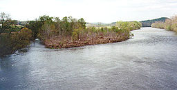
The North Fork of the Holston River near Weber City, Virginia.
|
|
| Country | United States |
|---|---|
| States | Virginia, Tennessee |
| Part of | Tennessee → Ohio → Mississippi |
| Primary source | North Fork Holston River |
| - location | Bland County, Virginia |
| - elevation | 2,880 ft (878 m) |
| - coordinates | 37°03′51″N 81°16′15″W / 37.06417°N 81.27083°W |
| Secondary source | South Fork Holston River |
| - location | Smyth County, Virginia |
| - elevation | 2,900 ft (884 m) |
| - coordinates | 36°46′11″N 81°22′04″W / 36.76972°N 81.36778°W |
| Source confluence | |
| - location | Kingsport, Tennessee |
| - elevation | 1,158 ft (353 m) |
| - coordinates | 36°32′51″N 82°36′44″W / 36.54750°N 82.61222°W |
| Mouth | Tennessee River |
| - location | Knoxville, Tennessee |
| - elevation | 814 ft (248 m) |
| - coordinates | 35°57′33″N 83°51′0″W / 35.95917°N 83.85000°WCoordinates: 35°57′33″N 83°51′0″W / 35.95917°N 83.85000°W |
| Length | 136 mi (219 km) |
| Basin | 3,776 sq mi (9,780 km2) |
| Discharge | for J. Will Taylor Bridge (Hwy. 70) near Knoxville, Tennessee, 5.5 miles (8.9 km) above the mouth |
| - average | 4,759 cu ft/s (135 m3/s) (mean for water years 1931–1975, 1979-1983) |
| - max | 62,900 cu ft/s (1,781 m3/s) March 1935 |
| - min | 44 cu ft/s (1.2 m3/s) December 1941 |
The Holston River is a 136-mile (219,000 m) river that flows from Kingsport, Tennessee, to Knoxville, Tennessee. Along with its three major forks (North Fork, Middle Fork and South Fork), it comprises a major river system that drains much of northeastern Tennessee, southwestern Virginia, and northwestern North Carolina. The Holston's confluence with the French Broad River at Knoxville marks the beginning of the Tennessee River.
The North Fork flows 138 miles (222 km) southwest from Sharon Springs in Bland County, Virginia. The Middle Fork flows 56.5 miles (90.9 km) from near the western border of Wythe County, Virginia, joining the South Fork in Washington County, Virginia, southeast of Abingdon. The South Fork rises near Sugar Grove in Smyth County and flows 112 miles (180 km) southwest to join the North Fork at Kingsport. The Watauga River, a tributary of the South Fork Holston, flows 78.5 miles (126,300 m) westward from Watauga County, North Carolina.
The main stem of the Holston is impounded by the Tennessee Valley Authority's Cherokee Dam near Jefferson City, Tennessee. Five other dams, also managed by TVA, impound the Holston's headwater streams: Watauga Dam and Wilbur Dam on the Watauga River, and Boone Dam, Fort Patrick Henry Dam, and South Holston Dam, on the South Fork Holston River.
...
Wikipedia


