Tehama, California
| City of Tehama | |
|---|---|
| City | |
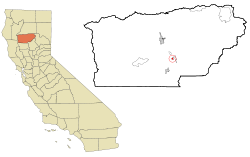
 Location in Tehama County and the state of California |
|
| Location in the United States | |
| Coordinates: 40°1′28″N 122°7′26″W / 40.02444°N 122.12389°WCoordinates: 40°1′28″N 122°7′26″W / 40.02444°N 122.12389°W | |
| Country |
|
| State |
|
| County | Tehama |
| Incorporated | July 5, 1906 |
| Area | |
| • Total | 0.794 sq mi (2.057 km2) |
| • Land | 0.794 sq mi (2.057 km2) |
| • Water | 0 sq mi (0 km2) 0% |
| Elevation | 210 ft (64 m) |
| Population (2010) | |
| • Total | 418 |
| • Density | 530/sq mi (200/km2) |
| Time zone | Pacific (PST) (UTC-8) |
| • Summer (DST) | PDT (UTC-7) |
| ZIP code | 96090 |
| Area code(s) | 530 |
| FIPS code | 06-78106 |
| GNIS feature ID | 1659964 |
| Website | cityoftehama |
Tehama is a city in Tehama County, California, United States. The population was 418 at the 2010 census, down from 432 at the 2000 census.
Tehama is located at 40°1′28″N 122°7′26″W / 40.02444°N 122.12389°W (40.024337, -122.123783).
According to the United States Census Bureau, the city has a total area of 0.8 square miles (2.1 km2), all of it land.
The 2010 United States Census reported that Tehama had a population of 418. The population density was 526.3 people per square mile (203.2/km²). The racial makeup of Tehama was 346 (82.8%) White, 6 (1.4%) African American, 23 (5.5%) Native American, 1 (0.2%) Asian, 0 (0.0%) Pacific Islander, 27 (6.5%) from other races, and 15 (3.6%) from two or more races. Hispanic or Latino of any race were 57 persons (13.6%).
The Census reported that 418 people (100% of the population) lived in households, 0 (0%) lived in non-institutionalized group quarters, and 0 (0%) were institutionalized.
...
Wikipedia

