Teaticket, Massachusetts
| Teaticket, Massachusetts | |
|---|---|
| Census-designated place | |

Teaticket School
|
|
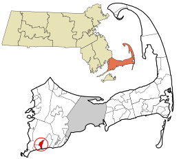
 Location in Barnstable County and the state of Massachusetts. |
|
| Coordinates: 41°33′29″N 70°35′13″W / 41.55806°N 70.58694°WCoordinates: 41°33′29″N 70°35′13″W / 41.55806°N 70.58694°W | |
| Country | United States |
| State | Massachusetts |
| County | Barnstable |
| Town | Falmouth |
| Area | |
| • Total | 1.4 sq mi (3.5 km2) |
| • Land | 1.0 sq mi (2.7 km2) |
| • Water | 0.3 sq mi (0.8 km2) |
| Elevation | 26 ft (8 m) |
| Population (2010) | |
| • Total | 1,692 |
| • Density | 1,606/sq mi (620.1/km2) |
| Time zone | Eastern (EST) (UTC-5) |
| • Summer (DST) | EDT (UTC-4) |
| ZIP code | 02536 |
| Area code(s) | 508 |
| FIPS code | 25-69205 |
| GNIS feature ID | 0616474 |
Teaticket /ˈtiːˌtɪkᵻt/ is a census-designated place (CDP) in the town of Falmouth in Barnstable County, Massachusetts, United States. The population was 1,692 at the 2010 census.
Teaticket is located in the southern part of the town of Falmouth at 41°33′29″N 70°35′13″W / 41.55806°N 70.58694°W (41.557934, -70.586815), between the villages of East Falmouth (to the east) and Falmouth (to the west). Massachusetts Route 28 runs east–west through the center of the village. South of 28, the CDP occupies a neck, bordered by Great Pond to the east and Little Pond to the west, that extends to Vineyard Sound. The neck is home to the Maravista neighborhood.
According to the United States Census Bureau, the Teaticket CDP has a total area of 1.4 square miles (3.5 km2), of which 1.0 square mile (2.7 km2) is land and 0.31 square miles (0.8 km2), or 21.90%, is water.
...
Wikipedia
