Tayug, Pangasinan
| Tayug | ||
|---|---|---|
| Municipality | ||

Tayug Welcome Arch
|
||
|
||
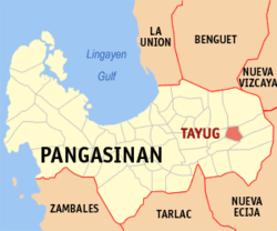
 Map of Pangasinan showing the location of Tayug |
||
| Location within the Philippines | ||
| Coordinates: 16°01′25″N 120°44′52″E / 16.02361°N 120.74778°ECoordinates: 16°01′25″N 120°44′52″E / 16.02361°N 120.74778°E | ||
| Country | Philippines | |
| Region | Ilocos (Region I) | |
| Province | Pangasinan | |
| District | 6th district of Pangasinan | |
| Barangays | 21 | |
| Government | ||
| • Mayor | Tyrone Damasen Agabas | |
| • Vice Mayor | Carlos Trece Mapili | |
| • Electorate | 25,600 voters (2016 election) | |
| Area | ||
| • Total | 51.24 km2 (19.78 sq mi) | |
| Population (2015 census) | ||
| • Total | 43,149 | |
| • Density | 840/km2 (2,200/sq mi) | |
| Time zone | PST (UTC+8) | |
| ZIP code | 2445 | |
| 015543000 | ||
| IDD : area code | +63 (0)75 | |
| Income class | 3rd municipal income class | |
| Revenue | ₱ 26,224,236.20 (2016) | |
| Poverty incidence | 6.71 (2012) | |
Tayug (Pangasinan: Baley na Tayug; Ilocano: Ili ti Tayug), is a 3rd class municipality in the province of Pangasinan, Philippines. According to the 2015 census, it has a population of 43,149 people.
The town of Tayug got its unique name not from people who were influential or from name of saints but from a very tall tree that once grew in the heart of the town; the bacayao tree was so tall that in Ilocano they call it “Layug”. In view of the difficulty of the people to pronounce the letter “L” they change it to letter “T” by common usage. Hence, the name Tayug came about.
Tayug is politically subdivided into 21 barangays.
...
Wikipedia


