Taylor County, Georgia
| Taylor County, Georgia | |
|---|---|

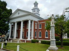
Taylor County Courthouse in Butler
|
|
 Location in the U.S. state of Georgia |
|
 Georgia's location in the U.S. |
|
| Founded | January 15, 1852 |
| Named for | Zachary Taylor |
| Seat | Butler |
| Largest city | Butler |
| Area | |
| • Total | 380 sq mi (984 km2) |
| • Land | 377 sq mi (976 km2) |
| • Water | 3.0 sq mi (8 km2), 0.8% |
| Population | |
| • (2010) | 8,906 |
| • Density | 24/sq mi (9/km²) |
| Congressional district | 2nd |
| Time zone | Eastern: UTC-5/-4 |
Taylor County is a county located in the west central portion of the U.S. state of Georgia. As of the 2010 census, the population was 8,906. The county seat and largest city is Butler.
Taylor County was created on January 15, 1852, by an act of the Georgia General Assembly from portions of Macon, Marion and Talbot counties.
The County is named for Zachary Taylor, twelfth President of the United States.
The land for building the courthouse was purchased from Andrew McCants, John T. Gray, John Sturdivant, John L. Parker, and a Mr. Covington. (from a meeting minutes March 8, 1852)
Militia districts in the county included Prattsburg 737, Hall 743, Reynolds 741, Butler 757, Cedar Creek 1071, and Whitewater 853.
According to the U.S. Census Bureau, the county has a total area of 380 square miles (980 km2), of which 377 square miles (980 km2) is land and 3.0 square miles (7.8 km2) (0.8%) is water.
Taylor County is dissected by the Fall Line geological formation. The upper half of the county is located in the Piedmont region and consists of gently rolling hills and clay-based soils. The lower half of the county is located in the Upper Atlantic Coastal Plain and is markedly flatter and the soil more sandy. The Flint River marks the entirety of the county's northeastern border.
...
Wikipedia
