Tavares, Florida
| Tavares, Florida | ||
|---|---|---|
| City | ||
| City of Tavares | ||

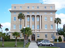
The Old Lake County Courthouse in March 2007
|
||
|
||
| Motto: "America's Seaplane City!" | ||
 Location in Lake County and the state of Florida |
||
| Coordinates: 28°48′6″N 81°44′1″W / 28.80167°N 81.73361°WCoordinates: 28°48′6″N 81°44′1″W / 28.80167°N 81.73361°W | ||
| Country | ||
| State |
|
|
| County |
|
|
| Incorporated | 1880 | |
| Area | ||
| • Total | 7.5 sq mi (19.3 km2) | |
| • Land | 7.1 sq mi (18.4 km2) | |
| • Water | 0.4 sq mi (0.9 km2) | |
| Elevation | 75 ft (23 m) | |
| Population (2000) | ||
| • Total | 9,700 | |
| • Estimate (2008) | 13,746 | |
| • Density | 1,300/sq mi (500/km2) | |
| Time zone | Eastern (EST) (UTC-5) | |
| • Summer (DST) | EDT (UTC-4) | |
| ZIP code | 32778 | |
| Area code(s) | 352 | |
| FIPS code | 12-71225 | |
| GNIS feature ID | 0292058 | |
| Website | Official website | |
Tavares (pronounced tuh-vair-ees) is a city located in the central portion of the U.S. state of Florida. It is the county seat of Lake County. The population in 2015 was 14,583, with a total of 5,000 households and an average household income of $40,000. It is part of the Orlando–Kissimmee–Sanford Metropolitan Statistical Area. The name is a popular Portuguese surname and toponym.
The city was founded by newspaper and railroad man Alexander St. Clair-Abrams in 1880 and named for a Portuguese ancestor. In 1883 a post office was established, which was followed by a hotel, three stores, a sawmill, and eight cottages in 1884. While St. Clair-Abrams did not achieve his dream that Tavares become the state capital of Florida (Tallahassee has held the spot since 1823), in 1887 the city was named the seat of Lake County. St. Clair-Abrams later chartered a railroad to run from Tavares to Orlando. In 1919, Tavares incorporated as a town.
Tavares is located at 28°48′6″N 81°44′1″W / 28.80167°N 81.73361°W (28.801670, -81.733548)
According to the United States Census Bureau, the city has a total area of 7.4 square miles (19 km2); of this, 7.1 square miles (18 km2) (95.16%) is land and 0.4 square miles (1.0 km2) (4.84%) is water.
As of the census of 2000, there were 9,700 people, 4,471 households, and 2,821 families residing in the city. The population density was 1,368.3 inhabitants per square mile (528.2/km2). There were 5,475 housing units at an average density of 772.3 per square mile (298.2/km2). The racial makeup of the city was 88.98% White, 7.70% African American, 0.30% Native American, 0.80% Asian, 0.07% Pacific Islander, 1.04% from other races, and 1.10% from two or more races. Hispanic or Latino of any race were 3.46% of the population.
...
Wikipedia

