Tauragė district municipality
|
Tauragė district municipality Tauragės rajono savivaldybė |
||
|---|---|---|
| Municipality | ||

|
||
|
||
 Location in Lithuania |
||
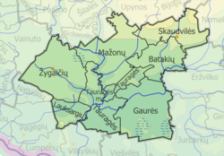
 Map of Tauragė district municipality |
||
| Coordinates: 55°17′53″N 22°21′11″E / 55.29806°N 22.35306°ECoordinates: 55°17′53″N 22°21′11″E / 55.29806°N 22.35306°E | ||
| Country |
|
|
| Ethnographic region | Samogitia | |
| County | Tauragė | |
| Capital | Tauragė | |
| Elderships | 8 | |
| Area | ||
| • Total | 1,179 km2 (455 sq mi) | |
| Area rank | 33rd | |
| Population (2016-01-20) | ||
| • Total | 40,790 | |
| • Rank | 14th | |
| • Density | 35/km2 (90/sq mi) | |
| • Density rank | 16th | |
| Time zone | EET (UTC+2) | |
| • Summer (DST) | EEST (UTC+3) | |
| Telephone code | 446 | |
| Major settlements | ||
| Website | www |
|
Tauragė District Municipality (Lithuanian: Tauragės rajono savivaldybė) is a municipality in Tauragė County, Lithuania
The Tauragė district municipality contains 8 seniūnijos (in English: elderships or wards); the main town or village is listed for each.
...
Wikipedia

