Taum Sauk
| Taum Sauk Mountain | |
|---|---|

Taum Sauk Mountain is part of a large parks-and-wilderness area.
|
|
| Highest point | |
| Elevation | 1,772 ft (540 m) |
| Prominence | 512 ft (156 m) |
| Listing | U.S. state high point 41st |
| Coordinates | 37°34′13″N 90°43′40″W / 37.5703266°N 90.7279003°WCoordinates: 37°34′13″N 90°43′40″W / 37.5703266°N 90.7279003°W |
| Geography | |
|
|
|
| Parent range | Saint Francois Mountains |
| Topo map | USGS Ironton |
| Climbing | |
| Easiest route | Hike |
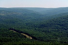
Taum Sauk Mountain /ˈtɔːm ˈsɔːk/ in the Saint Francois Mountains is the highest natural point in the U.S. state of Missouri at 1,772 feet (540 m). The topography of Taum Sauk is that of a somewhat flat ridge rather than a peak.
While relatively low in terms of elevation at 1,772 feet (540 m) compared to , Taum Sauk and the St. Francois range are true mountains, being the result of a volcanic orogeny. Whereas vertical relief in the rest of the Ozarks region is the result of erosion of sedimentary strata, the St. Francois are an ancient Precambrian igneous uplift several times older than the Appalachians. Geologists believe that Taum Sauk and its neighbors may be among the few areas in the US never to have been submerged in ancient seas. The peaks of the St. Francois range existed as islands in the shallow seaway throughout most of the Paleozoic Era as the sandstones, limestones, and shales typical of the Ozarks were deposited. Weathering and erosion of these ancient peaks provided the clastic sediments of the surrounding rock layers.
...
Wikipedia

