Tateyama, Toyama
|
Taeyama 立山町 |
|||
|---|---|---|---|
| Town | |||

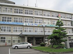
Tateyama Town Office
|
|||
|
|||
 Location of Tateyama in Toyama Prefecture |
|||
| Coordinates: 36°39′48.8″N 137°18′49.3″E / 36.663556°N 137.313694°ECoordinates: 36°39′48.8″N 137°18′49.3″E / 36.663556°N 137.313694°E | |||
| Country | Japan | ||
| Region | Chūbu (Hokuriku) | ||
| Prefecture | Toyama | ||
| District | Nakaniikawa | ||
| Area | |||
| • Total | 307.29 km2 (118.65 sq mi) | ||
| Population (October 2016) | |||
| • Total | 26,161 | ||
| • Density | 85.1/km2 (220/sq mi) | ||
| Time zone | Japan Standard Time (UTC+9) | ||
| Symbols | |||
| • Tree | Cryptomeria | ||
| • Flower | Chrysanthemum | ||
| • Flowering Tree | Satsuki azalea | ||
| Address | 2440 Maezawa, Tateyama-machi, Nakaniikawa-gun, Toyama-ken 930-0292 | ||
| Website | www |
||
Tateyama (立山町 Tateyama-machi?) is a town located in Nakaniikawa District, Toyama Prefecture, Japan. As of 1 October 2016[update], the town had an estimated population of 26,161 and a population density of 85.1 persons per km². The total area of the town was 307.29 square kilometres (118.65 sq mi).
Tateyama is located in east central Toyama Prefecture. The town is located in the Tateyama Mountain Range.
The area of present-day Tateyama was part of ancient Etchū Province. The village of Tatayama was created on May 12, 1894. It was elevated to town status pm January 10, 1954.
Tateyama has eight public elementary schools and one public middle school operated by the village government. There is one public high school operated by the Toyama Board of Education.
...
Wikipedia


