Tasman Council
|
Tasman Council Tasmania |
|||||||||||||
|---|---|---|---|---|---|---|---|---|---|---|---|---|---|

Tasman Council
|
|||||||||||||
| Coordinates | 43°05′S 147°52′E / 43.09°S 147.86°ECoordinates: 43°05′S 147°52′E / 43.09°S 147.86°E | ||||||||||||
| Population | 2,405 (2015 est) | ||||||||||||
| • Density | 3.644/km2 (9.44/sq mi) | ||||||||||||
| Area | 660 km2 (254.8 sq mi) | ||||||||||||
| Mayor | Roseanne Heyward (since 2014) | ||||||||||||
| Council seat | Nubeena | ||||||||||||
| Region | South East Tasmania, Australia | ||||||||||||
| State electorate(s) | Lyons | ||||||||||||
| Federal Division(s) | Lyons | ||||||||||||
 |
|||||||||||||
| Website | Tasman Council | ||||||||||||
|
|||||||||||||
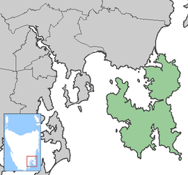
The Tasman Council is a local government area of Tasmania, covering the Tasman and Forestier Peninsulas. At the 2011 census, the local government area had a population of 2,355, that increases to over 8,000 at peak tourist times.
Port Arthur, Nubeena and Koonya are the main towns. The local government area contains the Tasman National Park and a large range of tourism sites including the former penal settlement of Port Arthur, now one of the eleven Australian Convict Sites listed on the World Heritage Register; Eaglehawk Neck and the Tessellated Pavement amongst many others.
Tasman Council is composed of seven Councillors elected using the Hare-Clark system of proportional representation as a single ward. All Councillors are elected for a fixed four-year term of office. The Mayor and Deputy Mayor are each directly elected for a four-year term. The Mayor and Deputy Mayor must also be elected as Councillors in order to hold office. Elections are normally held in October, with the next election due to be held in October 2018. Neither the Australian Labor Party nor the Liberal Party of Australia endorse local government candidates in Tasmania.
The most recent election of Councillors was held over a two-week period from 14 October to 28 October 2014, and the makeup of the Council is as follows:
The current Council, elected in 2014, in order of election, is:
...
Wikipedia
