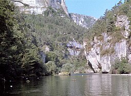
Tarn river
| Tarn | |
|
High cliffs in the Gorges du Tarn
|
|
| Country | France |
|---|---|
| Landmark | Gorges du Tarn |
| Source | Mont Lozère |
| - location | Cévennes, France |
| - elevation | 1,550 m (5,085 ft) |
| - coordinates | 44°24′53″N 3°48′54″E / 44.41472°N 3.81500°E |
| Mouth | Garonne |
| - location | Moissac, France |
| - coordinates | 44°05′10″N 1°02′33″E / 44.086111°N 1.0425°ECoordinates: 44°05′10″N 1°02′33″E / 44.086111°N 1.0425°E |
| Length | 381 km (237 mi) |
| Basin | 15,700 km2 (6,062 sq mi) |
| Discharge | |
| - average | 140 m3/s (4,944 cu ft/s) |
| Progression | Garonne→ Atlantic Ocean |
|
Tarn within France
|
|
The Tarn (Occitan: Tarn, Latin: Tarnis, possibly meaning 'rapid' or 'walled in') is a 381-kilometre (237 mi) long river in southern France (régions Languedoc-Roussillon and Midi-Pyrénées), right tributary of the Garonne.
The Tarn runs in a roughly westerly direction, from its source at an elevation of 1,550 m (5,085 ft) on Mont Lozère in the Cévennes mountains (part of the Massif Central), through the deep gorges and canyons of the Gorges du Tarn (that cuts through the Causse du Larzac), to Moissac in Tarn-et-Garonne, where it joins the Garonne 4 km (2.5 mi) downstream from the centre of town.
Its basin covers approximately 12,000 square kilometres (4,600 sq mi), and it has a mean flow of approximately 140 cubic metres per second (4,900 cu ft/s).
The Millau Viaduct spans the valley of the River Tarn near Millau, and is now one of the area's most popular attractions.
The tributaries of the Tarn include:
The Tarn separates the Narbonne and Aquitaine basins.
The Tarn passes through the following departments and towns:
...
Wikipedia


