Tarfaya
|
Tarfaya طرفاية ⵟⴰⵔⴼⴰⵢⴰ |
|
|---|---|

Tarfaya skyline
|
|
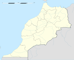
| Location in Morocco, as shown at bottom left. | |
| Coordinates: 27°56′22″N 12°55′34″W / 27.93944°N 12.92611°W | |
| Country |
|
| Region | Laâyoune-Sakia El Hamra |
| Province | Tarfaya Province |
| Population (2004) | |
| • Total | 5,615 |
| Time zone | WET (UTC+0) |
| • Summer (DST) | WEST (UTC+1) |
| Website | http://tarfaya.info |
Tarfaya (Arabic: طرفاية - Ṭarfāya; Berber: ⵟⴰⵔⴼⴰⵢⴰ) is a town, previously also known as Villa Bens during the Spanish period, located in the Tarfaya Province of the Laâyoune-Sakia El Hamra region of southwestern Morocco. It is a port town on the Atlantic coast, close to Cape Juby, which shares its name with the southern region of Morocco, and is located 890 km southwest of Rabat. According to the 2004 census, Tarfaya has a population of 5,615, the smallest of the four municipalities of the region, but it is the only one outside of the disputed Western Sahara.
In the 1920s, the French commercial air carrier Aéropostale constructed an airfield here. A small monument now stands at that site to honour the air carrier, its pilots in general and the French aviator and author Antoine de Saint-Exupéry in particular. He served as station manager here during his career as an airmail pilot.
Tarfaya was occupied by the British in 1882, when they built a trading post called Casa del Mar. The building is currently in a state of complete disrepair. The Sahrawi tribes then solicited the intervention of Sultan Hassan I who negotiated the withdrawal of the British in 1885 by acquiring their trading office. In 1912 the territory of Tarfaya, then named Cape Juby, was occupied by Spain as part of the Spanish Sahara. The greater Cape Juby region plus Tarfaya were unified with Morocco in 1958, at the end of the Ifni War.
In December 2014 the Tarfaya Wind Farm, largest wind farm in Africa, was commissioned.
...
Wikipedia

