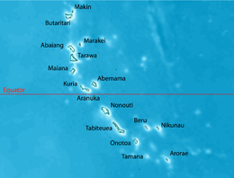
Tarawa

Map of South Tarawa (red) and North Tarawa (yellow) within Tarawa Atoll
|
|
| Geography | |
|---|---|
| Location | Pacific Ocean |
| Coordinates | 1°26′N 173°00′E / 1.433°N 173.000°E |
| Archipelago | Gilbert Islands |
| Area | 500 km2 (190 sq mi) |
| Highest elevation | 3 m (10 ft) |
| Administration | |
|
Kiribati
|
|
| Demographics | |
| Population | 56,284 (2010) |
Tarawa is an atoll and the capital of the Republic of Kiribati, in the central Pacific Ocean. It comprises North Tarawa, which has much in common with other, more remote islands of the Gilberts group; and South Tarawa, which is home to 50,182 as of 2010[update] – half of the country's total population. The atoll is best known by outsiders as the site of the Battle of Tarawa during World War II.
Tarawa has a large lagoon, 500 square kilometres (193 sq mi) total area, and a wide reef. Although naturally abundant in fish and shellfish of all kinds, marine resources are being strained by the large and growing population. Drought is frequent, but in normal years rainfall is sufficient to maintain breadfruit, papaya and banana trees as well as coconut and pandanus.
North Tarawa consists of a string of islets, with the most northern islet being Buariki. The islets are separated in places by wide channels that are best crossed at low tide.
On South Tarawa, the construction of causeways has now created a single strip of land from Betio in the West to Buota in the Northeast.
The climate is pleasant from April to October, with predominant northeastern winds and stable temperatures close to 30 °C (86 °F). From November to March, western gales bring rain and occasional cyclones.
Precipitation varies significantly between islands. For example, the annual average is 3,000 mm (120 in) in the north and 500 mm (20 in) in the south of the Gilbert Islands. Most of these islands are in the dry belt of the equatorial oceanic climatic zone and experience prolonged droughts.
Tarawa atoll has three administrative subdivisions:
South Tarawa hosts the capital of the Republic of Kiribati. The House of Assembly is in Ambo, and the State House is in Bairiki. The offices of the various ministries of the government range from Betio at the south-west extreme to Nawerewere (at the near-centre of North Tarawa in an easterly island in its chain).
...
Wikipedia

