Tara, County Meath
| Hill of Tara Cnoc na Teamhrach |
|
|---|---|

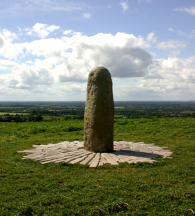
The Lia Fáil (Stone of Destiny) atop the Hill of Tara, County Meath
|
|
| Highest point | |
| Elevation | 155 m (509 ft) |
| Prominence | 84 m (276 ft) |
| Coordinates | 53°34′39″N 6°36′43″W / 53.57750°N 6.61194°WCoordinates: 53°34′39″N 6°36′43″W / 53.57750°N 6.61194°W |
| Geography | |
| Location | County Meath, Ireland |
The Hill of Tara (Irish: Cnoc na Teamhrach,Teamhair or Teamhair na Rí), located near the River Boyne, is an archaeological complex that runs between Navan and Dunshaughlin in County Meath, Ireland. It contains a number of ancient monuments and, according to tradition, was the seat of the High King of Ireland.
At the summit of the hill, to the north of the ridge, is an oval Iron Age hilltop enclosure, measuring 318 metres (1,043 ft) north-south by 264 metres (866 ft) east-west and enclosed by an internal ditch and external bank, known as Ráith na Ríogh (the Fort of the Kings, also known as the Royal Enclosure). The most prominent earthworks within are the two linked enclosures, a bivallate (double-ditched) ring fort and a bivallate ring barrow known as Teach Chormaic (Cormac's House) and the Forradh or Royal Seat. In the middle of the Forradh is a standing stone, which is believed to be the Lia Fáil (Stone of Destiny) at which the High Kings were crowned. According to legend, the stone would scream if a series of challenges were met by the would-be king. At his touch the stone would let out a screech that could be heard all over Ireland. To the north of the ring-forts is a small Neolithic passage tomb known as Dumha na nGiall (the Mound of the Hostages), which was constructed around 3,400 (cal.) BC.
To the north, just outside the bounds of the Ráith na Rí, is a ringfort with three banks known as Ráith na Seanadh (the Rath of the Synods). Excavations of this monument have produced Roman artefacts dating from the 1st–3rd centuries.
Farther north is a long, narrow rectangular feature known as the Banqueting Hall (Teach Miodhchuarta), although it is more likely to have been a ceremonial avenue or cursus monument approaching the site, and three circular earthworks known as the Sloping Trenches and Gráinne's Fort. All three are large ring barrows which may have been built too close to the steep declivity and subsequently slipped.
...
Wikipedia

