Tamar Bridge
| Tamar Bridge | |
|---|---|

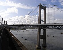
The Tamar Bridge from a train on the neighbouring Royal Albert Bridge, 2009
|
|
| Coordinates | 50°24′29.29″N 04°12′12.20″W / 50.4081361°N 4.2033889°WCoordinates: 50°24′29.29″N 04°12′12.20″W / 50.4081361°N 4.2033889°W |
| Carries | A38 trunk road |
| Crosses | River Tamar |
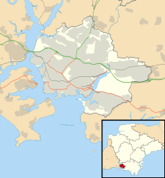
| Locale | Saltash – Plymouth in southwest England |
| Website | Official website |
| Characteristics | |
| Design | Suspension bridge |
| Longest span | 335 metres (1,099 ft) |
| History | |
| Constructed by | Cleveland Bridge & Engineering Company |
| Construction start | July 1959 |
| Construction end | October 1961 |
| Opened | 26 April 1962 |
| Rebuilt | 1999–2001 |
| Statistics | |
| Toll | £1.50 (cars) eastbound only |
The Tamar Bridge is a major road bridge over the River Tamar between Saltash, Cornwall and Plymouth, Devon in southwest England. It is 335 metres (1,099 ft) long, running adjacent to the Royal Albert Bridge, and part of the A38, a main road between the two counties.
During the 20th century, there was increasing demand to replace or supplement the Saltash and Torpoint ferries, which could not cope with the rise in motor traffic. After the Government refused to prioritise the project in the 1950s, it was self-financed by Plymouth City Council and Cornwall County Council. Construction was undertaken by the Cleveland Bridge & Engineering Company and began in 1959. It was unofficially opened in October 1961, with a formal presentation by Queen Elizabeth The Queen Mother in April 1962. A reconstruction of the bridge began in 1999 after it was found to be unable to support a European Union requirement for goods vehicle weights. The work involved building two new parallel decks while the original construction was completely rebuilt. The project was completed in late 2001 and formally opened by Princess Anne in April 2002. The extra decks have remained in use, increasing the bridge's capacity.
The bridge is tolled for eastbound travel, with a discount available via an electronic payment scheme. It has become a significant landmark in Plymouth, Saltash and the surrounding area, and used on several occasions for protests or to highlight the work of charities and fundraisers.
The bridge runs over the River Tamar from near Wearde, Saltash in the west to Riverside, Plymouth in the east. It has a central span of 335 metres (1,099 ft) and two side spans of 114 metres (374 ft). It is part of the A38, a major cross-country road that runs across Cornwall and Devon, and lies immediately north of the Royal Albert Bridge, a significant railway bridge designed by Isambard Kingdom Brunel that opened in 1859. Both bridges are north of the Hamoaze, the estuary that the Tamar feeds into, and the Torpoint Ferry.
...
Wikipedia

