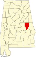
Tallapoosa County, Alabama
| Tallapoosa County, Alabama | |
|---|---|

County courthouse in Dadeville
|
|
 Location in the U.S. state of Alabama |
|
 Alabama's location in the U.S. |
|
| Founded | December 18, 1832 |
| Seat | Dadeville |
| Largest city | Alexander City |
| Area | |
| • Total | 766 sq mi (1,984 km2) |
| • Land | 717 sq mi (1,857 km2) |
| • Water | 50 sq mi (129 km2), 6.5% |
| Population (est.) | |
| • (2015) | 40,844 |
| • Density | 58/sq mi (22/km²) |
| Congressional district | 3rd |
| Time zone | Central: UTC-6/-5 |
| Website | www |
|
Footnotes:
|
|
Footnotes:
Tallapoosa County is a county of the U.S. state of Alabama. As of the 2010 census, the population was 41,616. Its county seat is Dadeville. The name Tallapoosa is of Creek origin; many Creek villages were located along the banks of the lower river before Indian Removal in the 19th century. Tallapoosa County was established by European Americans on December 18, 1832.
According to the U.S. Census Bureau, the county has a total area of 766 square miles (1,980 km2), of which 717 square miles (1,860 km2) is land and 50 square miles (130 km2) (6.5%) is water. The county is intersected by the Tallapoosa River.
As of the census of 2000, there were 41,475 people, 16,656 households, and 11,809 families residing in the county. The population density was 58 people per square mile (22/km2). There were 20,510 housing units at an average density of 29 per square mile (11/km2). The racial makeup of the county was 73.48% White, 25.36% Black or African American, 0.26% Native American, 0.18% Asian, 0.01% Pacific Islander, 0.17% from other races, and 0.54% from two or more races. Nearly 0.58% of the population were Hispanic or Latino of any race.
...
Wikipedia
