Talkeetna, Alaska
| Talkeetna, Alaska | |
|---|---|
| CDP | |
 |
|
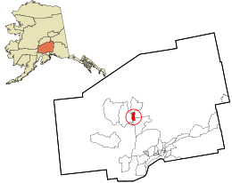
 Location in Matanuska-Susitna Borough and the state of Alaska. |
|
| Location within the state of Alaska | |
| Coordinates: 62°18′41″N 150°5′13″W / 62.31139°N 150.08694°WCoordinates: 62°18′41″N 150°5′13″W / 62.31139°N 150.08694°W | |
| Country | United States |
| State | Alaska |
| Borough | Matanuska-Susitna |
| Government | |
| • Borough mayor | Vern Halter |
| • State senator | Mike Dunleavy (R) |
| • State rep. | David Eastman (R) |
| Area | |
| • Total | 42.9 sq mi (111.2 km2) |
| • Land | 41.6 sq mi (107.7 km2) |
| • Water | 1.4 sq mi (3.6 km2) |
| Elevation | 348 ft (106 m) |
| Population (2010) | |
| • Total | 876 |
| • Density | 20/sq mi (7.9/km2) |
| Time zone | Alaska (AKST) (UTC-9) |
| • Summer (DST) | AKDT (UTC-8) |
| ZIP code | 99676 |
| Area code(s) | 907 |
| FIPS code | 02-74830 |
| GNIS feature ID | 1410591 |
Talkeetna (Dena'ina: K'dalkitnu) is a census-designated place (CDP) in Matanuska-Susitna Borough, Alaska, United States. It is part of the Anchorage, Alaska, Metropolitan Statistical Area. At the 2010 census the population was 876.
Talkeetna is located at 62°18′41″N 150°5′13″W / 62.31139°N 150.08694°W (62.311397, -150.087053) at the confluence of three rivers, the Susitna, Chulitna and Talkeetna. Talkeetna began in 1916 when the area was chosen as a district headquarters for the Alaska Railroad. A post office opened as well as a sawmill, trading post, cigar store and other businesses as well as many cabins. In 1917, the residents encouraged the government to survey the lots on which their homes stood. In 1919, the railroad surveyed and auctioned 80 lots, 41 of which already had permanent structures on them. The average price at the sale was $14.25. Flightseeing, rafting, mountain biking, hiking, camping, fishing and hunting make up a large portion of the local economy. Talkeetna is a 2.5 hour drive from Anchorage, the largest city in Alaska. The core downtown area is classified as a National Historic Site, with buildings dating from the early 1900s including Nagley's General Store, Fairview Inn and the Talkeetna Roadhouse.
According to the United States Census Bureau, the CDP has a total area of 42.9 square miles (111 km2), of which, 41.6 square miles (108 km2) of it is land and 1.4 square miles (3.6 km2) of it (3.19%) is water.
...
Wikipedia

