Talco, Texas
| Talco, Texas | |
|---|---|
| City | |
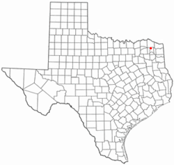
 Location of Talco, Texas |
|
 |
|
| Coordinates: 33°21′44″N 95°6′15″W / 33.36222°N 95.10417°WCoordinates: 33°21′44″N 95°6′15″W / 33.36222°N 95.10417°W | |
| Country | United States |
| State | Texas |
| County | Titus |
| Area | |
| • Total | 0.8 sq mi (2.0 km2) |
| • Land | 0.8 sq mi (2.0 km2) |
| • Water | 0.0 sq mi (0.0 km2) |
| Elevation | 364 ft (111 m) |
| Population (2010) | |
| • Total | 516 |
| • Density | 650/sq mi (260/km2) |
| Time zone | Central (CST) (UTC-6) |
| • Summer (DST) | CDT (UTC-5) |
| Zip Code | 75487 |
| FIPS code | 48-71732 |
| GNIS feature ID | 1369562 |
Talco is a city in Titus County, Texas, United States. The population was 516 at the 2010 census. The name is derived from a local candy bar (It was either a shelf carton or because the local people said it was "Texas-Arkansas-Louisiana Country hence Talco. Also reports said it may have been a local company name Texas-Arkansas-Louisian Company. There are varying reports to what it was actually.
Two post offices were established near the current site of Talco: Gouldsboro in 1856 and Goolesboro in 1878. Due to name conflict the community changed its name to "Talco" based on the Texas, Arkansas, and Louisiana Candy Company initials on a candy wrapper. In 1912, Talco relocated to be closer to a railroad line.
Oil was discovered in 1936, leading to a big boom in the economy. Talco called itself the "Asphalt capital of the world."
Talco is located at 33°21′44″N 95°6′15″W / 33.36222°N 95.10417°W (33.362131, -95.104090).
According to the United States Census Bureau, the city has a total area of 0.8 square miles (2.0 km²), all of it land.
US Route 271 is a major north-south highway through Talco. The community is a mile east of the Franklin County line.
As of the census of 2000, there were 570 people, 220 households, and 150 families residing in the city. The population density was 743.0 people per square mile (285.8/km²). There were 277 housing units at an average density of 361.1 per square mile (138.9/km²). The racial makeup of the city was 78.60% White, 12.81% African American, 8.25% from other races, and 0.35% from two or more races. Hispanic or Latino of any race were 13.16% of the population.
...
Wikipedia
