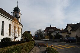
Tägerig
| Tägerig | ||
|---|---|---|

Tägerig village
|
||
|
||
| Coordinates: 47°24′N 8°17′E / 47.400°N 8.283°ECoordinates: 47°24′N 8°17′E / 47.400°N 8.283°E | ||
| Country | Switzerland | |
| Canton | Aargau | |
| District | Bremgarten | |
| Area | ||
| • Total | 3.29 km2 (1.27 sq mi) | |
| Elevation | 396 m (1,299 ft) | |
| Population (Dec 2015) | ||
| • Total | 1,455 | |
| • Density | 440/km2 (1,100/sq mi) | |
| Postal code | 5522 | |
| SFOS number | 4077 | |
| Surrounded by | Hägglingen, Mellingen, Niederwil, Stetten, Wohlenschwil | |
| Website |
www SFSO statistics |
|
Tägerig is a municipality in the district of Bremgarten in the canton of Aargau in Switzerland.
A number of shaped flints have been found north of the modern village, indicating that the area was inhabited before written records. The first mention of the modern village is in the 12th Century when it was mentioned as Tegrank. In 1189 it was mentioned as Tegeranc.
The Twingherrschaft region (which included Tägerig) was a Habsburg fief in the 14th Century, and was granted to the Knights of Rüssegg. In 1350 it went to the Freiherren of Wohlen, then in 1409 to Segesser of Brunegg and in 1543 to the City of Mellingen.
Tägerig initially belonged to the parish church of Niederwil. In 1669 a branch chapel was dedicated. After the devastating fire of 1838, a new church was built in 1846 and was made in 1864 into a separate parish.
Besides agriculture, in the 18th Century the straw plaiting industry was of major importance in the village. As this industry declined in the late 19th and early 20th Century, the population declined. By the 1920s much of the population commuted to jobs in Mellingen and Baden (in 1990, 76% of the working population commuted). For this reason, population growth remained moderate even after 1950.
Tägerig has an area, as of 2006[update], of 3.3 square kilometers (1.3 sq mi). Of this area, 42.9% is used for agricultural purposes, while 39.2% is forested. Of the rest of the land, 15.5% is settled (buildings or roads) and the remainder (2.4%) is non-productive (rivers or lakes).
The municipality is located in the Bremgarten district in the Reuss river valley. It consists of the village of Tägerig on the valley floor and the hamlets of Büschikon in the surrounding hills.
...
Wikipedia


