Szigetvár
| Szigetvár | ||
|---|---|---|

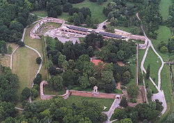
Aerial Photography: Szigetvár - Castle
|
||
|
||
| Coordinates: 46°02′54″N 17°48′45″E / 46.048269°N 17.812569°ECoordinates: 46°02′54″N 17°48′45″E / 46.048269°N 17.812569°E | ||
| Country |
|
|
| County | Baranya | |
| Area | ||
| • Total | 39.51 km2 (15.25 sq mi) | |
| Population (2009) | ||
| • Total | 10,900 | |
| • Density | 288.33/km2 (746.8/sq mi) | |
| Time zone | CET (UTC+1) | |
| • Summer (DST) | CEST (UTC+2) | |
| Postal code | 7900 | |
| Area code(s) | 73 | |
Szigetvár (Hungarian pronunciation: [ˈsiɡɛtvaːr]; Croatian: Siget; Turkish: Zigetvar; German: Inselburg) is a town in Baranya County in southern Hungary.
The town's fortress was the setting of the Battle of Szigetvár in 1566. It was a sanjak centre at first in Budin Province (1566–1601), later in Kanije Province (1601–1689). There was already a fortress in the marshland back in Celtic and Roman times. The former Andrássy Palace is next to them. Some other monuments in the town date back to Turkish times. Two years after the siege, the mosque of Ali Pasha was built, later - in 1788 - to be transformed into a Christian church: the Roman Catholic parish church. The two minarets, as well as the windows and niches with ogee arches indicate its original function. The Turkish House of red raw brick walls and interlaced steel window grills in Bástya Street was originally destined to be a caravanserai. The two holy-water basins of the Franciscan Church were made of Turkish washbasins. The carved main altar of the Baroque Church is another sight to see. In 1966, on the 400th anniversary of the siege, Szigetvár regained its old rank of a chartered ancient city. Development began to gather speed. Today it has a population of 12,000. In October 2011, the city received the title Civitas Invicta from the Hungarian Parliament.
...
Wikipedia


