Swissvale
| Swissvale | |
|---|---|
| Borough | |

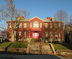
Longfellow School (1902)
National Register of Historic Places |
|
 Location of Swissvale in Allegheny County, Pennsylvania. |
|
| Coordinates: 40°25′20″N 79°53′10″W / 40.42222°N 79.88611°WCoordinates: 40°25′20″N 79°53′10″W / 40.42222°N 79.88611°W | |
| Country | United States |
| State | Pennsylvania |
| County | Allegheny |
| Area | |
| • Total | 1.24 sq mi (3.22 km2) |
| • Land | 1.20 sq mi (3.11 km2) |
| • Water | 0.04 sq mi (0.11 km2) |
| Population (2010) | |
| • Total | 8,983 |
| • Estimate (2016) | 8,769 |
| • Density | 7,301.42/sq mi (2,819.31/km2) |
| Time zone | Eastern (EST) (UTC-5) |
| • Summer (DST) | EDT (UTC-4) |
| ZIP codes | 15218 |
| FIPS code | 42-75816 |
| Website | Borough of Swissvale |
Swissvale is a borough in Allegheny County, Pennsylvania, 9 miles (14 km) east of downtown Pittsburgh. Named for a farmstead owned by James Swisshelm, during the industrial age it was the site of the Union Switch and Signal Company of George Westinghouse. The population was 8,983 at the 2010 census. In 1940, 15,919 people lived there.
Swissvale is located at 40°25′20″N 79°53′10″W / 40.42222°N 79.88611°W (40.422304, -79.886185).
According to the United States Census Bureau, the borough has a total area of 1.3 square miles (3.4 km2), of which 1.2 square miles (3.1 km2) is land and 0.1 square miles (0.26 km2), or 4.76%, is water.
Swissvale is bordered by Edgewood to the north, Braddock Hills to the east, North Braddock to the southeast, Rankin to the south, and the Pittsburgh neighborhoods of Regent Square and Swisshelm Park to the west. (The area known as Regent Square encompasses portions of Pittsburgh, Wilkinsburg, Edgewood, and Swissvale.) Directly across the Monongahela River to the southwest is the borough of Munhall.
...
Wikipedia
