Sweetwater River (Wyoming)
| Sweetwater River | |
|
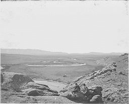
1870 photograph of the Sweetwater River.
|
|
| Country | United States |
|---|---|
| State | Wyoming |
| Cities | Sweetwater Station, Jeffrey City |
| Source | Sweetwater Gap |
| - location | Wind River Range, Fremont County |
| - elevation | 10,200 ft (3,109 m) |
| - coordinates | 42°39′15″N 109°03′25″W / 42.65417°N 109.05694°W |
| Mouth | North Platte River |
| - location | Pathfinder Reservoir, Natrona County |
| - elevation | 5,853 ft (1,784 m) |
| - coordinates | 42°30′25″N 109°03′25″W / 42.50694°N 109.05694°WCoordinates: 42°30′25″N 109°03′25″W / 42.50694°N 109.05694°W |
| Length | 238 mi (383 km) |
| Basin | 2,880 sq mi (7,459 km2) |
| Discharge | for above Pathfinder Reservoir |
| - average | 120.8 cu ft/s (3 m3/s) |
| - max | 4,290 cu ft/s (121 m3/s) |
| - min | 0.5 cu ft/s (0 m3/s) |
|
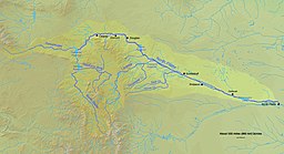
North Platte, Sweetwater Rivers across Wyoming
|
|
The Sweetwater River is a 238-mile (383 km) long tributary of the North Platte River, in the U.S. state of Wyoming. As a part of the Mississippi River system, its waters eventually reach the Gulf of Mexico.
The Sweetwater rises in southwestern Fremont County, at the continental divide near South Pass Wyoming, on the southern end of the Wind River Range. It flows ENE along the north side of the Antelope Hills, then ESE, through Fremont County, past Jeffrey City, between the Granite Mountains to the north and the Green Mountains (Wyoming) to the south, through what are now cattle-raising areas. In southern Natrona County, it passes Devil's Gate and Independence Rock along the Oregon, California and Mormon Trails, and empties into the North Platte as the Sweetwater arm of Pathfinder Reservoir.
The Sweetwater River valley provided a route used by fur trappers, mountain men and fur traders as they went to their annual summertime Rocky Mountain Rendezvous located usually somewhere along the Green River Wyoming. These trappers and traders soon established a path for their pack trains along the Sweetwater and eventually cleared a rough wagon trail to the Green River.
...
Wikipedia


