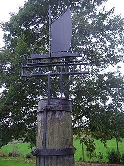
Swafield
| Swafield | |
|---|---|
 The Village sign |
|
| Swafield shown within Norfolk | |
| Area | 6.43 km2 (2.48 sq mi) |
| Population | 315 (parish, 2011 census) |
| • Density | 49/km2 (130/sq mi) |
| OS grid reference | TG2832 |
| • London | 132 miles (212 km) |
| Civil parish |
|
| District | |
| Shire county | |
| Region | |
| Country | England |
| Sovereign state | United Kingdom |
| Post town | NORTH WALSHAM |
| Postcode district | NR28 |
| Police | Norfolk |
| Fire | Norfolk |
| Ambulance | East of England |
| EU Parliament | East of England |
| UK Parliament | |
Swafield is a village and a civil parish in the English county of Norfolk. The village is 16.4 miles (26.4 km) north north east of Norwich, 10.1 miles (16.3 km) south south East of Cromer and 133 miles (214 km) north-east of London. The village lies 1.4 miles (2.3 km) north of the town of North Walsham. The village sits astride the B1145Kings Lynn to Mundesley road that dissects North Norfolk west to east. The nearest railway station is at North Walsham for the Bittern Line which runs between Cromer and Norwich. The nearest airport is Norwich International Airport. The parish had in 2001 census, a population of 273, including Bradfield and increasing to 315 at the 2011 Census. For the purposes of local government, the parish falls within the district of North Norfolk.
The name Swafield possibly originates from open land with a track from the Anglo Saxon words swaeth, meaning track, and feld, meaning field, often a forest clearing. The former is the origin of swath or swathe, the latter of field. The name may also mean therefore, open land with swathes, the latter being areas of cut, laying corn.
Swafield has an entry in the Domesday Book of 1085. In the great book Swafield is recorded by the name Suafelda, Suaffelda and Suauelda, the main landholders being Bishop William and William d'Ecouis with the main tenant being Ranulf brother of Ilger. The survey also mentions a church.
The North Walsham and Dilham Canal, which is the only canal in Norfolk, was constructed and opened in 1826, and is 8.7 miles long and runs from Swafield Bridge to a junction with the River Ant at Smallburgh. The canal was constructed with locks a little wider than most canals in the UK to accommodate the use of the Norfolk wherries, hence the image of a wherry on Swafield’s village sign.
...
Wikipedia

