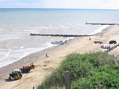
Mundesley
| Mundesley | |
|---|---|
 Mundesley Beach |
|
| Mundesley shown within Norfolk | |
| Area | 2.84 km2 (1.10 sq mi) |
| Population | 2,758 (parish, 2011 census) |
| • Density | 971/km2 (2,510/sq mi) |
| OS grid reference | TG315365 |
| • London | 136 miles (219 km) |
| Civil parish |
|
| District | |
| Shire county | |
| Region | |
| Country | England |
| Sovereign state | United Kingdom |
| Post town | NORWICH |
| Postcode district | NR11 |
| Dialling code | 01263 |
| Police | Norfolk |
| Fire | Norfolk |
| Ambulance | East of England |
| EU Parliament | East of England |
| UK Parliament | |
Mundesley is a coastal village and a civil parish in the English county of Norfolk. The village is 20.3 miles north-north east of Norwich, 7.3 miles south east of Cromer and 136 miles north east of London. The village lies 5.6 miles north-north east of the town of North Walsham. The nearest railway station is at North Walsham for the Bittern Line which runs between Cromer and Norwich. The nearest airport is Norwich Airport. The village sits astride the B1159 coast road that links Cromer and Caister-on-Sea, and is at the eastern end of the B1145 a route which runs between King's Lynn and Mundesley. Mundesley is within the Norfolk Coast AONB. It has a resident population of around 2,695 (parish, 2001 census), measured at 2,758 in the 2011 Census. The River Mun or Mundesley Beck flows into the sea here.
Mundesley has an entry in the Domesday Book of 1085. In the great book Mundesley is recorded by the name of Muleslai. The main landholder was William de Warenne, and the survey also lists a church.
The Mundesley war memorial is dedicated to sailors and volunteers who cleared the North Sea of mines during and after the Second World War. Next to the church is a World War II gun emplacement, which now stands near the edge of the cliff, due to coastal erosion.
An electoral ward in the same name exists. This ward includes Bacton and had had total population at the 2011 Census of 4,191.
...
Wikipedia

