Susitna River
| Susitna River | |
|---|---|

Susitna River in Southcentral Alaska
|
|
| Country | United States |
| Basin | |
| Main source | 2,500 ft (760 m) 63°26′10″N 147°11′55″W / 63.43611°N 147.19861°WSusitna Glacier on Mount Hayes |
| River mouth | 0 ft (0 m) 61°16′14″N 150°34′33″W / 61.27056°N 150.57583°WCoordinates: 61°16′14″N 150°34′33″W / 61.27056°N 150.57583°WCook Inlet of Pacific Ocean, at Matanuska-Susitna Borough, Alaska |
| Basin size | 20,000 sq mi (52,000 km2) |
| Physical characteristics | |
| Length | 313 mi (504 km) |
| Discharge |
|
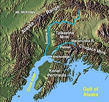
The Susitna River /suːˈsɪtnə/ (Sasut Na’ in Ahtna or Susitnu in Dena'ina) is a 313-mile (504 km) long river in the Southcentral Alaska. It is the 15th largest river in the United States, ranked by average discharge volume at its mouth. The river stretches from the Susitna Glacier to Cook Inlet's Knik Arm.
Dena'ina Indian name meaning "sandy river" published by the Russian Hydrog. Dept. as "R(eka) Sushitna," meaning Sushitna River, on Chart 1378 dated 1847. The Susitna River appears to have been first explored in 1834, by a "Creole named Malakov", and the name may have been obtained by the Russians at that time. The present spelling of the name has evolved due to euphemistic reasons.
The Susitna River heads at Susitna Glacier, in Alaska Range, flows southwest to Cook Inlet, 24 miles (39 km) west of Anchorage, Alaska Cook Inlet Low.
There are several rivers flowing into the Susitna River including East Fork Susitna River and West Fork Susitna River. The Little Susitna River is a separate river system which flows into the Cook Inlet on the other side of Susitna Flats.
...
Wikipedia
