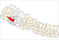
Surkhet
|
Surkhet Jillā सुर्खेत जिल्ला |
|
|---|---|
| District | |
 Location of Surkhet |
|
| Country | Nepal |
| Region | Mid-Western (Madhya Pashchimanchal) |
| Zone | Bheri |
| Headquarters | Birendranagar |
| Area | |
| • Total | 2,451 km2 (946 sq mi) |
| Population (2011) | |
| • Total | 350,804 |
| • Density | 140/km2 (370/sq mi) |
| Time zone | NPT (UTC+5:45) |
| Website | www.ddcsurkhet.gov.np |
Surkhet District (Nepali: , Surkhet Jillā ![]() Listen ) is one of Nepal's seventy-five districts of Nepal located about 600 kilometres (373 mi) west of the national capital Kathmandu. Surkhet is one of ten districts in Province No. 6. The district's area is 2,451 km². It had 288,527 population in 2001 and 350,804 in 2011. Birendranagar is the district headquarters, nominated for capital of the proposed Bheri-Karnali state of the new federal republic.
Listen ) is one of Nepal's seventy-five districts of Nepal located about 600 kilometres (373 mi) west of the national capital Kathmandu. Surkhet is one of ten districts in Province No. 6. The district's area is 2,451 km². It had 288,527 population in 2001 and 350,804 in 2011. Birendranagar is the district headquarters, nominated for capital of the proposed Bheri-Karnali state of the new federal republic.
Surkhet Valley is one the Inner Terai Valleys of Nepal. Bordering districts are Jajarkot, Dailekh, and Achham to the north, Bardiya and Kailali to the south, Salyan district to the east, and Doti to the west.
Unlike the cold weather of the Karnali mountain region and hot weather of the Outer Terai region, Surkhet has a more moderate climate. Winter temperatures drop to about 5 °C and in summer it goes up to 38 °C. Monsoon brings sufficient rainfall during the rainy season.
...
Wikipedia
