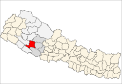
Salyan District, Nepal
|
Salyan District सल्यान जिल्ला |
|
|---|---|
| District | |
 Salyan (red) |
|
| Country | Nepal |
| Region | Mid-Western (grey) |
| Headquarters | Salyan |
| Area | |
| • Total | 1,462 km2 (564 sq mi) |
| Population (2011) | |
| • Total | 241,716 |
| • Density | 170/km2 (430/sq mi) |
| Time zone | NPT (UTC+5:45) |
| Website | ddcsalyan |
Salyan District (Nepali: ![]() Listen ), is a "hill" district some 320 km west of Kathmandu in Province No. 6 in midwestern Nepal. Salyan covers an area of 1,462 km² with a population of 213,500 in 2001 and 241,716 in 2011. The district's administrative center is named Salyan or Salyan Khalanga.
Listen ), is a "hill" district some 320 km west of Kathmandu in Province No. 6 in midwestern Nepal. Salyan covers an area of 1,462 km² with a population of 213,500 in 2001 and 241,716 in 2011. The district's administrative center is named Salyan or Salyan Khalanga.
The district is known for its Hindu temples including Shiva temples in Chhayachhetra and Laxmipur, and the Devi temple at Khairabang in Hiwalcha VDC, one of nine in Nepal.
Salyan was one of the Baise Rajya, a confederation of 22 petty kingdoms in the Karnali (Ghagra) region. About 1760 AD all these kingdoms were annexed by the Shah Dynasty during the unification of Nepal.
Salyan derives from the Nepali word sallo which means pine tree or conifer.
Although Salyan is considered a hilly district, its southwest salient is actually outside the Pahari-inhabited hill region, in the lower Siwalik Hills that are more an extension of the Terai.
...
Wikipedia
