Surgoinsville, Tennessee
| Surgoinsville, Tennessee | |
|---|---|
| Town | |

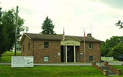
Surgoinsville City Hall
|
|
 Location of Surgoinsville, Tennessee |
|
| Coordinates: 36°28′27″N 82°51′15″W / 36.47417°N 82.85417°WCoordinates: 36°28′27″N 82°51′15″W / 36.47417°N 82.85417°W | |
| Country | United States |
| State | Tennessee |
| County | Hawkins |
| Government | |
| • Mayor | Merrell Graham |
| Area | |
| • Total | 4.1 sq mi (10.6 km2) |
| • Land | 4.0 sq mi (10.5 km2) |
| • Water | 0.0 sq mi (0.1 km2) |
| Elevation | 1,122 ft (342 m) |
| Population (2011)Estimate | |
| • Total | 1,796 |
| • Density | 367.2/sq mi (141.8/km2) |
| Time zone | Eastern (EST) (UTC-5) |
| • Summer (DST) | EDT (UTC-4) |
| ZIP code | 37857 and 37873 |
| Area code(s) | 423 |
| FIPS code | 47-72380 |
| GNIS feature ID | 1303949 |
| Website | www |
Surgoinsville is a town in Hawkins County, Tennessee, United States. The 2010 census showed a population of 1,801. It is part of the Kingsport–Bristol (TN)–Bristol (VA) Metropolitan Statistical Area, which is a component of the Johnson City–Kingsport–Bristol, TN-VA Combined Statistical Area – commonly known as the "Tri-Cities" region.
Surgoinsville was incorporated in 1815, and was named for its founder, Major James Surguine, a French Huguenot.
According to the United States Census Bureau, Surgoinsville has a total area of 4.1 square miles (11 km2), of which 4.0 square miles (10 km2) is land and 0.04 square miles (0.10 km2) (0.98%) is water.
As of the census of 2000, there were 1,484 people, 614 households, and 453 families residing in the town. The population density was 367.2 people per square mile (141.8/km²). There were 674 housing units at an average density of 166.8 per square mile (64.4/km²). The racial makeup of the town was 98.18% White, 0.34% African American, 0.34% Native American, 0.27% from other races, and 0.88% from two or more races. Hispanic or Latino of any race were 1.55% of the population.
...
Wikipedia
