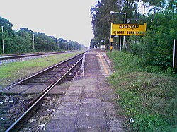
Suratkal
|
Surathkal ಸುರತ್ಕಲ್ |
|
|---|---|
| Suburb | |

Surathkal Railway Station
|
|
| Coordinates: 12°59′24″N 74°48′30″E / 12.99000°N 74.80833°ECoordinates: 12°59′24″N 74°48′30″E / 12.99000°N 74.80833°E | |
| Country |
|
| State | Karnataka |
| District | Dakshina Kannada |
| Region | Coastal Karnataka |
| Elevation | 24 m (79 ft) |
| Population | |
| • Total | 61,259 |
| Languages | |
| • Official | Kannada |
| • Regional | Tulu, Konkani |
| Time zone | IST (UTC+5:30) |
| PIN | 575014 |
| Telephone code | 0824 |
| Vehicle registration | KA-62 |
Surathkal is a suburb of Mangalore city located on National highway 66 (previously as NH-17) in the Dakshina Kannada district, Karnataka state, India on the shore of Arabian sea. It is a municipality merged with Mangalore City Corporation. It lies between Gurupura ( Phalguni ) and Pavanje ( Nandini ) rivers. It can be considered as the northernmost area of Mangalore City Corporation geographical limits. Surathkal is 6 kilometres north of New Mangalore seaport.
According to legend, the name Surathkal is derived from "shiratakal" meaning "headstone" in Tulu. The famous Sadashiva temple on the shores of Arabian Sea (Lakshadweepa samudra ) is said to be built around the linga that a Rakshasa by name Kharasura carried on his head. Another legend is that When Ravana threw in fit of rage the atma shivalinga some of the pieces from shivalinga were fallen at place where Sadashiva temple is at present. Noted historian Padoor Gururaj Bhat is of opinion the temple might have been constructed around 11 C.E. ( 11 A.D ).
Surathkal was once a Grama panchayat, then town panchayat, municipality now merged with Mangalore City Corporation. Surathkal was once a constituency of Karnataka Legislative assembly. Now it has been renamed as Mangalore North after change in its geographical limits. The Suratkal legislative assembly constituency was part of Udupi Loksabha constituency till 2009.
...
Wikipedia
