Sunset Beach, North Carolina
| Sunset Beach, North Carolina | |
|---|---|
| Seaside town | |

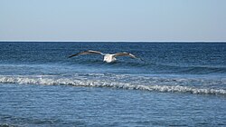
Seagull over wave in Sunset Beach
|
|
| Location within the state of North Carolina | |
| Coordinates: 33°52′7″N 78°30′25″W / 33.86861°N 78.50694°WCoordinates: 33°52′7″N 78°30′25″W / 33.86861°N 78.50694°W | |
| Country | United States |
| State | North Carolina |
| County | Brunswick |
| Township | Shallotte Township |
| Area | |
| • Total | 7.3 sq mi (19.0 km2) |
| • Land | 6.4 sq mi (16.7 km2) |
| • Water | 0.9 sq mi (2.3 km2) |
| Elevation | 10 ft (3 m) |
| Population (2010) | |
| • Total | 3,572 |
| • Density | 554/sq mi (213.9/km2) |
| Time zone | Eastern (EST) (UTC-5) |
| • Summer (DST) | EDT (UTC-4) |
| ZIP code | 28468 |
| Area code(s) | 910 |
| FIPS code | 37-65900 |
| GNIS feature ID | 1004755 |
| Website | www |
Sunset Beach is a seaside town in Brunswick County, North Carolina, United States. The population was 3,572 at the 2010 census, up from 1,824 at the 2000 census. It is part of the Myrtle Beach metropolitan area.
The seaside town of Sunset Beach had its start in 1955 when the land it occupies was bought by a property developer. Development began in earnest with the completion of a bridge connecting the beach island to the mainland in 1958. Sunset Beach was incorporated as a town in 1963.
Sunset Beach is located in southwestern Brunswick County at 33°53′7″N 78°30′27″W / 33.88528°N 78.50750°W (33.885348, -78.507528). It is the last developed Atlantic Ocean beach before the South Carolina border. One-third of the town's area occupies a barrier island between the ocean and the Intracoastal Waterway; the remainder of the town extends onto the mainland to the north. Undeveloped Bird Island is directly to the west, Calabash is the closest town to the west on the mainland, and Ocean Isle Beach is to the east.
According to the United States Census Bureau, the town of Sunset Beach has a total area of 7.3 square miles (19.0 km2). 6.4 square miles (16.7 km2) of it is land, and 0.89 square miles (2.3 km2) of it (12.22%) is water.
...
Wikipedia

