Sunset, UT
| Sunset, Utah | |
|---|---|
| City | |

Sunset City Offices
|
|
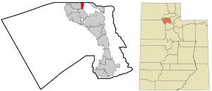
 Location in Davis County and the state of Utah |
|
| Coordinates: 41°8′26″N 112°1′47″W / 41.14056°N 112.02972°WCoordinates: 41°8′26″N 112°1′47″W / 41.14056°N 112.02972°W | |
| Country | United States |
| State | Utah |
| County | Davis |
| Incorporated | 1935 |
| Government | |
| • Mayor | Beverly MacFarlane |
| Area | |
| • Total | 1.3 sq mi (3.4 km2) |
| • Land | 1.3 sq mi (3.4 km2) |
| • Water | 0.0 sq mi (0.0 km2) |
| Elevation | 4,511 ft (1,375 m) |
| Population (2010) | |
| • Total | 5,122 |
| • Density | 3,911/sq mi (1,509.9/km2) |
| Time zone | Mountain (MST) (UTC-7) |
| • Summer (DST) | MDT (UTC-6) |
| ZIP code | 84015 |
| Area code(s) | 385, 801 |
| FIPS code | 49-74480 |
| GNIS feature ID | 1433075 |
| Website | sunset-ut |
Sunset is a city in Davis County, Utah, United States. It is part of the Ogden–Clearfield, Utah Metropolitan Statistical Area. The population was 5,122 at the 2010 census.
Sunset emerged as a distinct place in 1916.
Sunset is located in northern Davis County. It is bordered by Hill Air Force Base to the east, Clearfield to the south, Clinton to the west, and Roy in Weber County to the north.
According to the United States Census Bureau, the city of Sunset has a total area of 1.3 square miles (3.4 km2), all of it land.
As of the census of 2000, there were 5,204 people, 1,785 households, and 1,435 families residing in the city. The population density was 3,532.3 people per square mile (1,366.9/km²). There were 1,832 housing units at an average density of 1,243.5 per square mile (481.2/km²). The racial makeup of the city was 86.88% White, 1.56% African American, 0.92% Native American, 2.75% Asian, 0.15% Pacific Islander, 4.73% from other races, and 3.02% from two or more races. Hispanic or Latino of any race were 10.51% of the population.
...
Wikipedia
