Summit Township, Butler County, Pennsylvania
| Summit Township, Butler County, Pennsylvania |
|
|---|---|
| Township | |

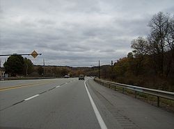
Along U.S. Route 422 in Summit Township
|
|
 Map of Butler County, Pennsylvania highlighting Summit Township |
|
 Map of Butler County, Pennsylvania |
|
| Country | United States |
| State | Pennsylvania |
| County | Butler |
| Settled | 1796 |
| Incorporated | 1854 |
| Area | |
| • Total | 22.5 sq mi (58.4 km2) |
| • Land | 22.5 sq mi (58.3 km2) |
| • Water | 0.04 sq mi (0.1 km2) |
| Population (2010) | |
| • Total | 4,884 |
| • Density | 217/sq mi (83.8/km2) |
| Time zone | Eastern (EST) (UTC-5) |
| • Summer (DST) | EDT (UTC-4) |
| Website | summittwp |
Summit Township is a township in Butler County, Pennsylvania, United States. The population was 4,884 at the 2010 census.
Summit Township is located in east-central Butler County, just east of the city of Butler, the county seat. The township surrounds the borough of East Butler but is separate from it. The unincorporated communities of Herman, Brinker, Vogleyville, Bonnie Brook, Wadsworth, and Carbon Center are located in the township.
U.S. Route 422, the Benjamin Franklin Highway, crosses the township, connecting Butler to the west with Kittanning to the east.
According to the United States Census Bureau, the township has a total area of 22.5 square miles (58.4 km2), of which 22.5 square miles (58.3 km2) is land and 0.04 square miles (0.1 km2), or 0.18%, is water.
As of the census of 2000, there were 4,728 people, 1,682 households, and 1,269 families residing in the township. The population density was 212.1 people per square mile (81.9/km²). There were 1,755 housing units at an average density of 78.7/sq mi (30.4/km²). The racial makeup of the township was 95.43% White, 3.98% African American, 0.02% Native American, 0.21% Asian, 0.02% from other races, and 0.34% from two or more races. Hispanic or Latino of any race were 0.78% of the population.
...
Wikipedia
