Summerland, British Columbia
| Summerland | ||
|---|---|---|
| District municipality | ||
| The Corporation of the District of Summerland | ||

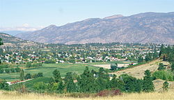
A view of Summerland
|
||
|
||
| Nickname(s): Town of Festivals | ||
| Location of Summerland in British Columbia | ||
| Coordinates: 49°36′02″N 119°40′40″W / 49.60056°N 119.67778°W | ||
| Country |
|
|
| Province |
|
|
| Region | South Okanagan | |
| Regional District | Okanagan-Similkameen | |
| Founded | 1902 | |
| Government | ||
| • Mayor | Peter Waterman | |
| Area | ||
| • Total | 73.88 km2 (28.53 sq mi) | |
| Elevation | 454 m (1,490 ft) | |
| Population (2011) | ||
| • Total | 11,280 | |
| • Density | 150/km2 (400/sq mi) | |
| Postal code | V0H | |
| Area code(s) | +250 | |
| Website | summerland.ca | |
Summerland (2011 population 11,280) is a town on the west side of Okanagan Lake in the interior of British Columbia, Canada. The district is between Peachland to the north and Penticton to the south. The largest centre in the region is Kelowna, approximately 50 km to the north (via Highway 97), and Vancouver is approximately 425 km (264 mi) away to the west. The district is famous for "Bottleneck drive", a system of roads connecting a large number of wineries.
The current Mayor is Peter Waterman. The district's (2016 federal) Member of Parliament is Dan Albas. Its (provincial) Member of Legislative Assembly is Liberal cabinet minister; Dan Ashton.
In 2006, the District of Summerland celebrated its centennial as an incorporated municipality in 1906, yet the history of settlement in the Summerland area extends beyond that time. Summerland's first inhabitants were the Okanagan Salish with the Nation's boundaries extending from Kamloops to southern Washington State. The area known as "Nicola Prairie" was notably named after the Grand Chief Nicola.
A published map of the Okanagan Valley in 1827 includes only three sites for the entire Okanagan Valley; Nicola Prairie; Lone Tree (north end of Summerland); and Sandy Cove (across the lake from present day Kelowna). Summerland's proud and diverse past includes hunting and fur trading, ranching, orchards and fruit industries, transportation hubs and more recently, tourism. Immigration to the Summerland area commenced in the late 1880s when the first settlers arrived and began diverting water to irrigate orchards. The first commercial orchard was planted in the 1890s in Trout Creek, where a water license was issued to irrigate 1,000 acres.
The first settlement identified on maps of the Okanagan Valley was Priest Encampment located on the shores of Garnett Lake. Later development began on the shores of Okanagan Lake. The upper benches continued to be an important transportation route and a number of small communities were constructed or were planned for development. They included Upper Trout Creek, Balcomo, the Prairie Valley Townsite, Mineola and Appledale. In 1892 Upper Trout Creek was established.
Summerland's former name was Trout Creek. In the 1890s George Barclay operated the largest cattle ranch in Trout Creek. In 1902 Sir Thomas Shaughnessy bought the Barclay Ranch and formed Summerland; incorporation was not completed until 1906. By the 1920s the present location of downtown Summerland was developed and the earlier areas on the upper benches were not utilized or forgotten. Downtown Summerland (Siwash Flat) was originally part of the Penticton Indian Reserve No. 3 (exchanged between 1904-06 following a mutually agreeable land deal). The subject lands eventually became known as West Summerland.
...
Wikipedia


