Sultanpur, Uttar Pradesh
| Sultanpur | |
|---|---|
| City | |

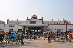
Railway Station – Sultanpur Junction
|
|
| Coordinates: 26°27′N 82°07′E / 26.450°N 82.117°ECoordinates: 26°27′N 82°07′E / 26.450°N 82.117°E | |
| Country |
|
| State | Uttar Pradesh |
| District | Sultanpur |
| Founded by | Ala-ud-Din Khilji |
| Elevation | 95 m (312 ft) |
| Population (2011) | |
| • Total | 116,211 |
| • Density | 855/km2 (2,210/sq mi) |
| Demonym(s) | Sultanpuria |
| Languages | |
| • Official | Hindi, Urdu |
| Time zone | IST (UTC+5:30) |
| PIN | 228001 |
| Vehicle registration | UP-44 |
| Sex ratio | 904:1000 ♂/♀ |
| Website | sultanpur |
Sultanpur is a city and a Municipal Board in Sultanpur District in the Indian state of Uttar Pradesh. Located on the right banks of the Gomti river (a major tributary of the Himalayan Ganga River), Sultanpur is the administrative headquarters of Sultanpur District and is a part of Faizabad Division. According to the 2011 Indian census, Sultanpur has a population of 116,211 people. Total area occupied by Sultanpur is 4436 km2. The common language of the people of Sultanpur is Awadhi, dialect of Hindi.
Sultanpur is distinguished for its unique culture. , Sultanpur (सुलतानपुर), literally "City of beautiful vines (सुन्दर लताओं का नगर)", the name is however often confused for "सुल्तानपुर - City of Sultan . The city came under the Muslim rule in the 12th century. Although the area has been part of successive North Indian kingdoms through centuries, the recorded history of the city began in the colonial times. Long a center of Hindu and Buddhist culture it fell under Muslim occupation in the 12th century. The town was completely destroyed during the military operations of the Revolt of 1857.
Places of interest in Sultanpur are Victoria Manzil, Christ Church and Chimanlal Park. The city has a large number of temples and palaces. Major points of attractions include the Victoria Manzil and Christ Church.
The Sultanpur district Gazetteer published in 1903 A.D. sheds some light on the history and origin of the district. It notes that the chief land owning families of the time were the Rajputs of various clans, who possessed 76.16% of the total land area mainly resided in place today known as narayanpur. Among them Raghuvanshies and the Rajkunwars popularly known as Rajkumar thakurs along-held over one-fourth of the district, while their kinsmen, the Bachgotis and Rajwars owned 11.4 and 3.4%, respectively. They had their haveli in narayanpur has been parted now by their ancestors. The Rajkunwars traced there ancestry to Hammir Dev Chauhan of Ranthambore.The Rajkunwars were the only ruling clans of Sultanpur to unite all the other clans of the area under one flag and form a grand State around the 16th century under Maharaj Bariarshah Rajkunwar of Bhaddaiyan Raj but the state and power of Rajkunwars was dissolved after the great uprising of 1857 as they supported the natives.The victorious British forces demoted the state to a zamindari and the Raja of dera was given the title of the heads of Rajkunwar. The head of rajkumar and raghuvanshi's thakur was raja ARJUN SINGH. The head of Bachgotis was the Raja of Kurwar while the taluqdar of Samrathpur represented another branch of the family. The chief of Rajwars was the taluqdar of Pratabpur. Another member of the Rajwars family was the Raja of Hasanpur. Laterly raja hasanpur family, and royal family of Narayanpur parted themselves and the royal faimly of narayanpur lived in narayanpur but as "daan" many of their land and resources they gave to hasanpur. Allied to him were the families of Maniarpur and Gangeo and between them they owned a large portion of the central area. Next to Bachgotis and their kinsmen come the Bandhalgotis, who owned almost the whole of Amethi pargana. Their head was the Raja of Amethi, while the taluqdar Shahgarh belonged to the same clan. Till now royal family of narayanpur started to giving "dan" to needy and poor people and their vast empire was degrading day by day. Raja Arjun singh told his son Bhagwandas to always support his praja. These were the last words of king. After them the Rajputs with large properties in the district were the Bhale Sultans who owned 4.72%, the Kanhapurias with 4.7%, and the Bais with 2.8%. Bhale Sultans were dwelling in the north west corner of the district in the parganas of Isauli, Musafirkhana and Jagdishpur. The Kanhpurias were chiefly confined to pargana Gaura Jamo, almost the whole of which belonged to them. The Bais were scattered about in small groups.
...
Wikipedia

