Sujawal District
|
Sujawal District ضلعو سجاول |
|
|---|---|
| District | |
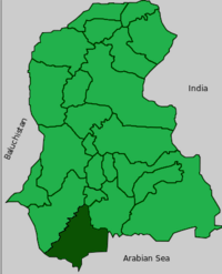
 Map of Sindh with Sujawal District highlighted |
|
| Country | Pakistan |
| Province | Sindh |
| Capital | Sujawal |
| Established | 12 October 2013 |
| Area | |
| • Total | 7,335 km2 (2,832 sq mi) |
| Time zone | PST (UTC+5) |
| Number of Tehsils | 4 |
| Website | borsindh.gov.pk/ |
Sujawal Dictrict (also spelled Sajawal; Sindhi: ضلعو سجاول, Urdu: ضلع سجاول) is a new district of the Sindh province of Pakistan. It is located at 24°36'23" of North and 68°4'19" of East and is bordered in the northwest by the Indus river which separates it from Thatta District. The district has an area of 7335 km².
The newly formed district is being made to smooth the administrative affairs of the area. Sujawal District is subdivided into four tehsils Jaati, Bathoro, Shah Bandar and Sujawal and 30 Union Councils.
The decision to divide Thatta District into two districts by the provincial government was made on 12 October 2013 through a notification issued by Revenue Department of Sindh. The provincial revenue department said…
A new district encompassing Sujawal, Kharochhan (barring 10 dehs), Mirpur Bathoro, Jaati and Shah Bundar tehsils (talukas) would be Sindh’s 28th district to be called Sujawal. Its headquarters will be located in Sujawal tehsil (taluka). The new district has been established under Section 6 of the Sindh Land Revenue Act, 1967.
...
Wikipedia
