Sudhnuti
| Sudhanoti | |
|---|---|
| District | |
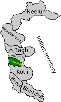
 Map of Azad Kashmir with Sudhanoti highlighted |
|
| Country | Pakistan |
| Headquarters | Pallandri |
| Area | |
| • Total | 569 km2 (220 sq mi) |
| Population (2017) | |
| • Total | 297,584 |
| • Density | 523/km2 (1,350/sq mi) |
| Time zone | PST (UTC+5) |
| Number of Tehsils | 4 |
Sudhanoti (also spelled Sudhanuti) (Urdu: ضلع سدھنوتی ) is one of the eight districts of Azad Kashmir in Pakistan. Sudhanoti is located at Latitude 33° 42′ 54″ N, Longitude 73° 41′ 9″ E. It is located 90 km away from Islamabad, the Capital of Pakistan. It is connected with Rawalpindi and Islamabad through Azad Pattan road.
Sudhanoti District is divided into four Tehsils Pallandri Balloch, Mong and Trarkhal. Pallandri is the district headquarters. It is at an elevation of 1372 meters and is at a distance of 97 Kilometers from Rawalpindi via Azad Pattan. The district is connected to Rawalakot by a 64-km metaled road.
Sudhanoti was carved out of Poonch district in 1995. The district is bounded by Poonch District in the north, Kotli in the south, and Punjab in the west. The total area of the district is 569 square kilometers.
Sudhanoti District is divided into four tehsils:
The city of Pullandri is the District Headquarters.
Sudhanoti has a population of 297,584 according to the 2017 Census. 97% is rural and 3% is urban. Males 51% and Females 49%. The main tribes are Sudhans. Its population includes Sudhans, Awans, Abbasis, Bains Rajput, Dar, Kianis, Syeds, Gardezis, Douli Mughals Khawaja, Butt, Qureshi etc. and many others. There is also a significant number of people from other regions who live in Sudhanoti for sake of employment. Annual Growth rate is 3%.
...
Wikipedia
