Sucre Municipality, Miranda
| Municipio Sucre (Sucre Municipality) |
|||
|---|---|---|---|

Dulce Nombre de Jesús de Petare Church
|
|||
|
|||
 Sucre in Miranda State |
|||
| Coordinates: 10°29′N 66°49′W / 10.483°N 66.817°WCoordinates: 10°29′N 66°49′W / 10.483°N 66.817°W | |||
| Country |
|
||
| State | Miranda | ||
| Seat | Petare | ||
| Founded | February 17, 1621 | ||
| Incorporated | 1989 | ||
| Government | |||
| • Mayor | Carlos Ocariz (Primero Justicia) | ||
| Area | |||
| • Total | 164 km2 (63 sq mi) | ||
| Population (2016) | |||
| • Total | 691,317 | ||
| • Density | 4,200/km2 (11,000/sq mi) | ||
| Time zone | VST (UTC-4:30) | ||
| • Summer (DST) | not observed (UTC-4:30) | ||
| Area code(s) | 0212 | ||
| Website | www.alcaldiamunicipiosucre.gov.ve | ||
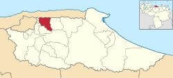
Sucre Municipality is one of the 21 municipalities (municipios) that makes up the Venezuelan state of Miranda and one of the municipalities that make up the Metropolitan District of Caracas. According to a 2016 population estimate by the National Institute of Statistics of Venezuela, the municipality has a population of 691,317. The city of Petare is the administrative centre of the Sucre Municipality. The municipality is one of several in Venezuela named "" in honour of Venezuelan independence hero Antonio José de Sucre.
The Sucre Municipality, according to a 2016 population estimate by the National Institute of Statistics of Venezuela, has a population of 691,317 (up from 591,414 in 2000). This amounts to 2.2% of the state's population. The municipality's population density (2016) is about 11,000 people per square mile (4,200/km²).
(Re elected)
...
Wikipedia


