Succasunna-Kenvil, New Jersey
| Succasunna-Kenvil, New Jersey | |
|---|---|
| Former census-designated place | |
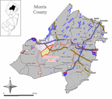
 Map of Succasunna-Kenvil CDP in Morris County. Inset: Location of Morris County in New Jersey. |
|
| Coordinates: 40°51′41″N 74°38′48″W / 40.86139°N 74.64667°WCoordinates: 40°51′41″N 74°38′48″W / 40.86139°N 74.64667°W | |
| Country |
|
| State |
|
| County | Morris |
| Township | Roxbury |
| Area | |
| • Total | 17.6 km2 (6.8 sq mi) |
| • Land | 17.3 km2 (6.7 sq mi) |
| • Water | 0.3 km2 (0.1 sq mi) |
| Population (2000 Census) | |
| • Total | 12,569 |
| • Density | 727.5/km2 (1,884.3/sq mi) |
| Time zone | Eastern (EST) (UTC-5) |
| • Summer (DST) | Eastern (EDT) (UTC-4) |
| FIPS code | 3471385 |
Succasunna-Kenvil is a former census-designated place (CDP) located within Roxbury Township, in Morris County, New Jersey, United States. As of the 2000 United States Census, the CDP's population was 12,569. For the 2010 Census, the area was split into two CDPs, Succasunna (with a 2010 census population of 9,152) and Kenvil (3,009 as of 2010).
According to the US Census Bureau, the CDP had a total area of 17.6 km2 (6.8 mi²). 17.3 km2 (6.7 mi2) of land and 0.3 km2 (0.1 mi2) of water (1.77%).
The 2000 United States Census counted 12,569 people, 4,138 households, and 3,475 families residing in the CDP. The population density was 727.6/km2 (1,884.3/mi2). The total of 4,184 housing units had a density of 242.2/km2 (627.3/mi2). The racial makeup of the CDP was 92.99% White, 1.34% Black or African American, 0.1% Native American, 4.11% Asian, 0.0% Pacific Islander, 0.67% from other races, and 0.81% from two or more races. 3.87% of the population were Hispanic or Latino of any race.
...
Wikipedia
