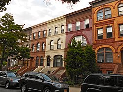
Stuyvesant Heights, Brooklyn
| Bedford–Stuyvesant | |
|---|---|
| Neighborhood of Brooklyn | |
 |
|
| Nickname(s): Bed-Stuy, Stuyford | |
| Location | |
| Coordinates: 40°41′20″N 73°56′40″W / 40.68889°N 73.94444°WCoordinates: 40°41′20″N 73°56′40″W / 40.68889°N 73.94444°W | |
| Country | United States |
| State | New York |
| City | New York City |
| Borough | Brooklyn |
| Area | |
| • Total | 2.782 sq mi (7.21 km2) |
| Population (2011) | |
| • Total | 157,530 |
| • Density | 57,000/sq mi (22,000/km2) |
| Ethnicity | |
| • White | 10.1% |
| • Black | 70.1% |
| • Hispanic | 15.0% |
| • Asian | 1.8% |
| • Other | 3.0% |
| Economics | |
| • Median income | $37,518 |
| ZIP codes | 11205, 11206, 11216, 11221, 11233, 11238 |
|
Stuyvesant Heights Historic District
|
|

On Decatur Street
|
|
| Location | Roughly bounded by Macon, Tompkins, Decatur, Lewis, Chauncey, and Stuyvesant, New York, New York |
|---|---|
| Coordinates | 40°40′52″N 73°56′14″W / 40.68111°N 73.93722°W |
| Area | 42 acres (17 ha) |
| Built | 1870 |
| Architectural style | Italianate, Queen Anne, Romanesque |
| NRHP Reference # | |
|
Stuyvesant Heights Historic District (Boundary Increase)
|
|
| Location | Roughly, Decatur St. from Tompkins to Lewis Aves., Brooklyn, New York |
| Area | 10 acres (4.0 ha) |
| Architect | multiple |
| Architectural style | Italianate, Second Empire, Queen Anne |
| NRHP Reference # | 96001355 |
| Added to NRHP | November 15, 1996 |
| Added to NRHP | December 4, 1975 |
Bedford–Stuyvesant (/ˈbɛdfərdˈstaɪvəsənt/; colloquially known as Bed–Stuy and occasionally Stuyford) is a neighborhood of 153,000 inhabitants in the north central portion of the New York City borough of Brooklyn. The neighborhood is part of Brooklyn Community Board 3, Brooklyn Community Board 8, and Brooklyn Community Board 16. The neighborhood is patrolled by the NYPD's 79th and 81st precincts. In the City Council, the district is represented by Robert Cornegy of the 36th Council District.
Bedford–Stuyvesant is bordered by Flushing Avenue to the north (bordering Williamsburg), Classon Avenue to the west (bordering Clinton Hill), Broadway to the east (bordering Bushwick), and Atlantic Avenue to the south (bordering Crown Heights and Brownsville). It is served by Postal Service ZIP codes 11205, 11206, 11216, 11221, 11233, and 11238. The main north–south thoroughfare is Nostrand Avenue, but the main shopping street is Fulton Street; the latter lies above the main subway line for the area, on the A C trains. Fulton Street runs east–west the length of the neighborhood and intersects high-traffic streets including Bedford Avenue, Nostrand Avenue, and Stuyvesant Avenue. Bedford–Stuyvesant is actually made up of four neighborhoods: Bedford, Stuyvesant Heights, Ocean Hill, and Weeksville (also part of Crown Heights). Part of Clinton Hill used to be considered part of Bedford–Stuyvesant.
...
Wikipedia


